Archaeology, Art History, Cymru, Europe, Ewrop, History, Literature, Poetry, Shropshire, Sir Amwythig, Wales

The Trees of Tilstock Park

My Manchester Metropolitan University page: http://www2.mmu.ac.uk/hpp/research/current-phd-students/

Please help fund my research: http://www.gofundme.com/medievalgardensandparks – just over 50% funded to date.

My Academia.edu page: http://mmu.academia.edu/SpencerGavinSmith

This week we are on the Shropshire / Flintshire border looking at Tilstock Park (Longitude 52.931698; Latitude -2.710032). The earliest date for a park at Tilstock is 1361 when it is recorded in an ‘Inquisition Post Mortem’. An Inquisition Post Mortem recorded the lands held at their deaths by tenants of the crown.

If want to know more – have a look at http://www.inquisitionspostmortem.ac.uk: “The project will publish a searchable English translation of the IPMs covering the periods 1236 to 1447 and 1485 to 1509. From 1399 to 1447 the text will be enhanced to enable sophisticated analysis and mapping of the inquisitions’ contents. The online texts will be accompanied by a wealth of commentary and interpretation to enable all potential users to exploit this source easily and effectively.”

Back to our particular Inquisition taken in 1361, which was taken on the death of Ankaretta Lestrange. Although the park is not recorded prior to 1361, it must have been in existence prior to this date for it to be included. From 1361 to the end of the century there are records of the Parkers (those officials responsible for maintaining the parks) but in this post I want to look at the ‘death’  of the park, rather than its ‘life’.

During my research I found this image which was published in Rowley, T. 1972 ‘The Shropshire Landscape’, Hodder and Stoughton, London.
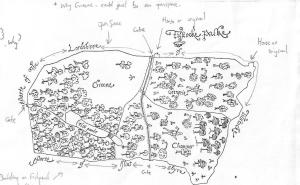
Tilstock Park c.1600
Tilstock Park c.1600.

(The annotations are mine on a photocopy before anyone thinks the book was defaced!)

This map – produced c.1600 – shows the ‘death’ of Tilstock Park. With the trees being chopped down by men equipped with axes. Having looked at this map in the book, I wasn’t happy with the reproduction of the original as some things didn’t look quite right, and it said in the book there there was no north marked on it.
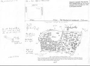
Annotations on a copy of Tilstock Park c.1600
Annotations on a copy of Tilstock Park c.1600.

I thought I’d use my copy as it shows my ‘workings out’, and gives some idea of how I look for clues, both in maps and in the landscape. Firstly, the original map does have north marked on it, it just happens that it is written in Latin.
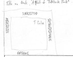
Latin words for 'North', 'South', 'East' and 'West' around the edge of the original map
Latin words for ‘North’, ‘South’, ‘East’ and ‘West’ around the edge of the original map.

Septentrionales = North / Meridies = South / Oriens = East / Occidens = West

Another way of orientating the map would be to look at where the county of Flintshire is marked, and in this case the county of Flintshire should be to the west of the county of Shropshire. So, with the map orientated, what other clues can we glean from the map?

Tilstock Park in its final incarnation had two gates, one on the western side and one on the eastern side. The gate on the western side had a park lodge outside of the park on the northern side, and there was another building in the north western corner of the park. On the southern side of the park was a water gate which allowed the flow of water to be controlled into a series of fish ponds on the south eastern side.
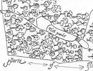
Fish Ponds in Tilstock Park
Fish Ponds in Tilstock Park.

Rowley thought that the park was divided into three – and in the ownership of Greene, Chawner and Gregorie. However, although Chawner and Gregorie appear to be depicted on the map, with axes over their shoulder, there is no sign of Greene. It would appear that in this case Greene refers to an open space, something we would expect to find in a medieval park.
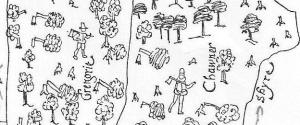
Chawner and Gregorie depicted with axes
Chawner and Gregorie depicted with axes.

Chawner and Gregorie are probably felling the trees in Tilstock Park in order to see them off and make some money as they change the use of the park from something which would have derived its income from a variety of sources, for example from the deer and other animals kept in the park, from the fish in the ponds and from the sale of wood. The park would now become an open space used as farmland, in this case pasture for sheep or cows.

Armed with the knowledge the original map was kept in the Shropshire Archives in Shrewsbury, I went to see why it hadn’t been reproduced in the book and why Rowley had made a copy. When I saw the original, I quickly understood why. The map was in several shades of green with black ink illustrations on top. This meant it was very difficult to read, and even more difficult to photograph.

So, what does Tilstock Park look like today?
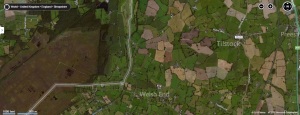
Tilstock Park Today
Tilstock Park Today in the wider landscape.

The most obvious feature visible in the park from the air is the site of the former fish ponds.
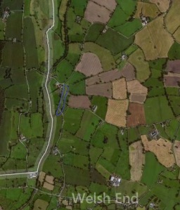
Tilstock Park Today. The edge of the former fish ponds is highlighted in blue
Tilstock Park Today. The edge of the former fish ponds is highlighted in blue.

The boundaries of the park are also clearly visible, and next week we’ll look inside the park in greater detail to see what else can be identified in the archaeological record.

Uncategorized

Don’t Panic!…It’s only a first draft…

The first draft of Chapter One has been returned. And so begins the process of listening to your head (your Supervisor) and not your heart (you). I read through the feedback, took it in and feel pretty good about what it says. Of course, there is the word ‘CUT’ written in places, which you come to expect having spoken to other PhD students who have gone before you, but overall it’s all pretty positive.

I’m a lot less defensive about my work now. I remember when I started by PhD in 2004 I was very protective of what I had written. I was right, of course I was right, I knew the material better than anyone! And maybe I did, but being able to tell the story on paper is a completely different thing. Standing in front of an audience, speaking without notes and weaving all my story threads together I’m very good at what I do. Writing it down is an art you learn and I’m glad to be learning.

. 164rabbits

It’s quite easy to feel like a rabbit in the headlights at the moment. The donations to http://www.gofundme.com/medievalgardensandparks have stopped – although I have more twitter followers than I did when I started the campaign and about a twentieth of my followers are still tweeting my message. Is this normal? To be honest I don’t know the answer, and seeing as no one else I’ve ever spoken to is doing something like this, I don’t know who to ask or where to turn to.

But I’m not giving up on getting this research completed am I? No. As those of you who have signed up to receive the updates of the blog will know – I’m comfortable with the material, and know where my lack of knowledge needs to be improved. Importantly, I think – and so do the people who have been kind enough to fund me – that this research needs to reach a wider audience. So, I have a study plan, and I’ve entered all the important dates into my ‘generic online character’ (other ‘generic online calendars’ are available) so I know where I am in keeping to the timetable I’m allowed.

There hasn’t been much in the way of research to be able to talk about this week, as I’ve been preparing to make a research trip to Shropshire Archives to try and complete the documentary study of the landscapes in that part of the world. I’m fortunate that the archive in Shrewsbury is a lovely, bright and comfortable place to work and the staff are excellent, so a visit there always manages to be a worthwhile trip…whether I leave with one reference or a ream of maps…to be honest, it tends to be the latter!

The-entrance-of-Shropshire-Archives

So. If you’ll excuse me, I have forms to fill in for the University, and thank you for your support.

Uncategorized

‘To Begin at the Beginning’…or ‘Has Anyone Seen That Confounded Bridge?’

Lines from Dylan Thomas ‘Under Milk Wood’ and Led Zeppelin ‘The Crunge’. Which probably seem to be an odd way to start a blog on Medieval Parks, Gardens and Designed Landscapes. However, in their own way, they have led to this blog being written. So, I thought I’d attempt to explain why I feel I should blog on this topic (although I am sure other topics will find a place at some point).

My name is Spencer Gavin Smith and I currently work as an archaeologist in the contracts section of the Gwynedd Archaeological Trust, who are based in Bangor, North West Wales.

My blog will be about the research I have been carrying out for my PhD thesis entitled ‘Parks, Gardens and Designed Landscapes of Medieval North Wales and North West Shropshire’. As it is still a work in progress, the blog will highlight why I’m carrying out the research, and how the disciplines of Archaeology, History, Literature and Art all entwine to make this topic so interesting to study.

I’m from the town of Wrexham in North East Wales, (Latitude 53.045083; Longitude -2.9931521). I went to both Welsh Language Primary and Secondary Schools, so I’m comfortable using either language. I chose to read Heritage Conservation at Bournemouth University for my Undergraduate Degree, and during my second year, I was, like most other students at that time of their University lives, casting around for a dissertation.

One day, I was in the University Bookshop and I saw a paperback entitled ‘The Revolt of Owain Glyn Dŵr’, written by someone called R.R. Davies. I’d not done history at GCSE, and at A Level the curriculum I studied covered the 19th and 20th centuries. I was aware of Owain Glyn Dŵr – what school child, and especially one in North East Wales where he came from, couldn’t fail to have heard of him. But beyond a few basic facts I didn’t really know very much at all.

So I bought the book.

And within a few pages I was hooked. Not by any inherent nationalism fuelled by being in a University on the south coast of England but by the beautiful way the book was written. I ‘understood’ for the first time how history can be brought to life by the deft touch of someone who has a mastery of the sources at their fingertips. I curated that book – it became something I involved and devoted my time to in order to try and gain some understanding of a world which occupied the same space as I had growing up, but a very different time.

But, I found there was a problem with the book, and one I wanted to solve.  

Within the chapter on Owain Glyn Dŵr was a small section which dealt with his house, known as Sycharth (which probably translates as Sych ‘Dry’ and (g)arth ‘Courtyard’). According to R.R. Davies there was a contemporary poem which described the house and its surroundings, and the photograph of Sycharth published in the book showed that the site was still there and had not been built upon. In addition to the poem, in 1966 an archaeological excavation report had been published about work on the site.

Which all left me confused. If the poem described the site, and archaeologists had excavated there, why had R.R. Davies written so little?

I had my dissertation topic. Now to start on the research.