Archaeology, Art History, Cymru, Europe, Ewrop, History, Literature, Poetry, Shropshire, Sir Amwythig, Wales

The Trees of Tilstock Park

My Manchester Metropolitan University page: http://www2.mmu.ac.uk/hpp/research/current-phd-students/

Please help fund my research: http://www.gofundme.com/medievalgardensandparks – just over 50% funded to date.

My Academia.edu page: http://mmu.academia.edu/SpencerGavinSmith

This week we are on the Shropshire / Flintshire border looking at Tilstock Park (Longitude 52.931698; Latitude -2.710032). The earliest date for a park at Tilstock is 1361 when it is recorded in an ‘Inquisition Post Mortem’. An Inquisition Post Mortem recorded the lands held at their deaths by tenants of the crown.

If want to know more – have a look at http://www.inquisitionspostmortem.ac.uk: “The project will publish a searchable English translation of the IPMs covering the periods 1236 to 1447 and 1485 to 1509. From 1399 to 1447 the text will be enhanced to enable sophisticated analysis and mapping of the inquisitions’ contents. The online texts will be accompanied by a wealth of commentary and interpretation to enable all potential users to exploit this source easily and effectively.”

Back to our particular Inquisition taken in 1361, which was taken on the death of Ankaretta Lestrange. Although the park is not recorded prior to 1361, it must have been in existence prior to this date for it to be included. From 1361 to the end of the century there are records of the Parkers (those officials responsible for maintaining the parks) but in this post I want to look at the ‘death’  of the park, rather than its ‘life’.

During my research I found this image which was published in Rowley, T. 1972 ‘The Shropshire Landscape’, Hodder and Stoughton, London.

Tilstock Park c.1600
Tilstock Park c.1600.

(The annotations are mine on a photocopy before anyone thinks the book was defaced!)

This map – produced c.1600 – shows the ‘death’ of Tilstock Park. With the trees being chopped down by men equipped with axes. Having looked at this map in the book, I wasn’t happy with the reproduction of the original as some things didn’t look quite right, and it said in the book there there was no north marked on it.

Annotations on a copy of Tilstock Park c.1600
Annotations on a copy of Tilstock Park c.1600.

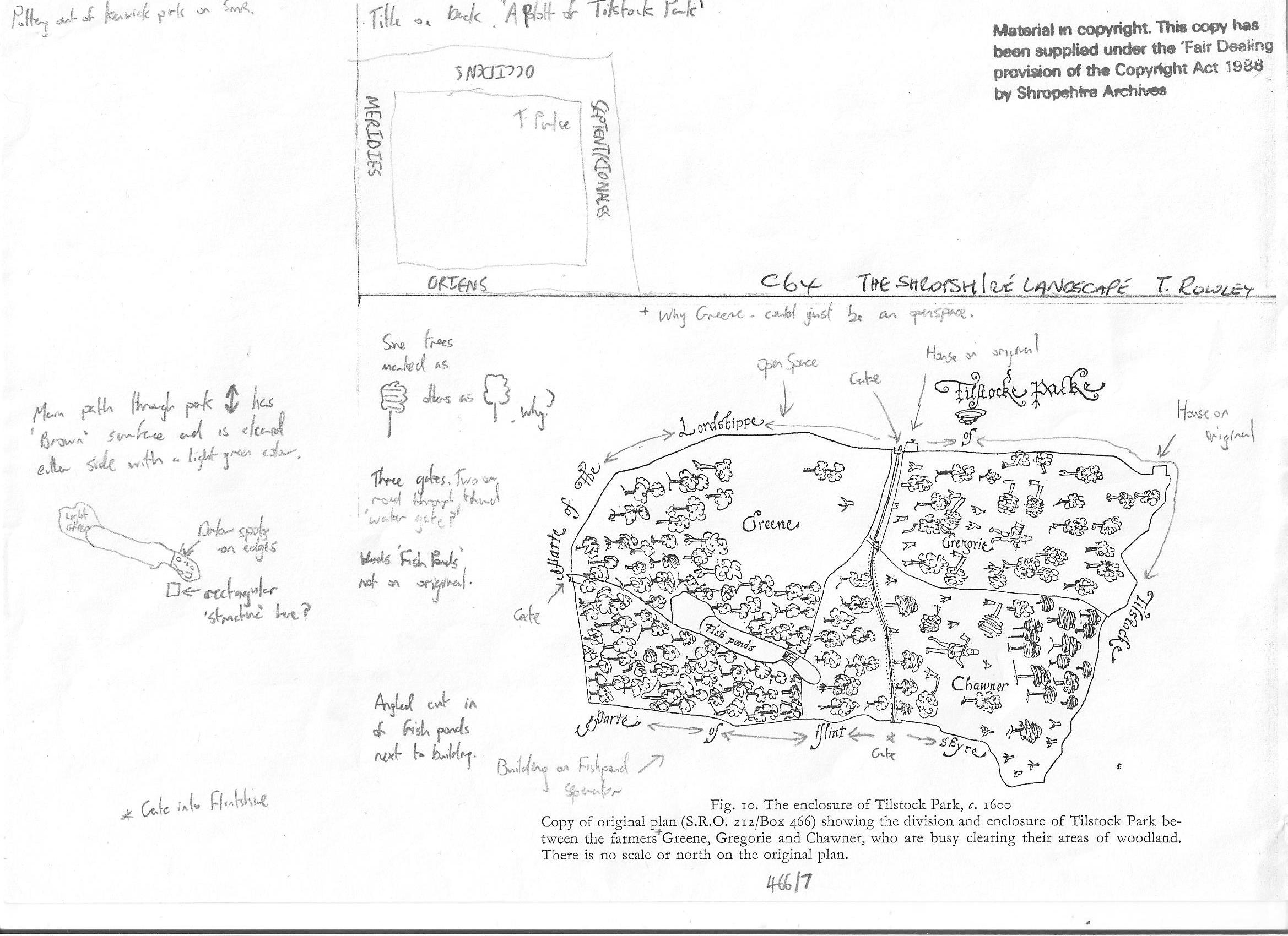
I thought I’d use my copy as it shows my ‘workings out’, and gives some idea of how I look for clues, both in maps and in the landscape. Firstly, the original map does have north marked on it, it just happens that it is written in Latin.

Latin words for 'North', 'South', 'East' and 'West' around the edge of the original map
Latin words for ‘North’, ‘South’, ‘East’ and ‘West’ around the edge of the original map.

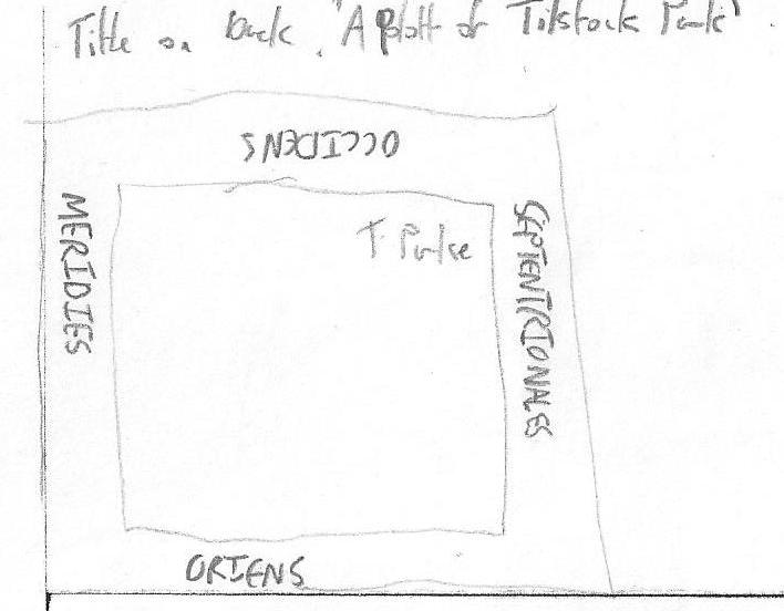
Septentrionales = North / Meridies = South / Oriens = East / Occidens = West

Another way of orientating the map would be to look at where the county of Flintshire is marked, and in this case the county of Flintshire should be to the west of the county of Shropshire. So, with the map orientated, what other clues can we glean from the map?

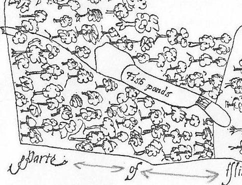
Tilstock Park in its final incarnation had two gates, one on the western side and one on the eastern side. The gate on the western side had a park lodge outside of the park on the northern side, and there was another building in the north western corner of the park. On the southern side of the park was a water gate which allowed the flow of water to be controlled into a series of fish ponds on the south eastern side.

Fish Ponds in Tilstock Park
Fish Ponds in Tilstock Park.

Rowley thought that the park was divided into three – and in the ownership of Greene, Chawner and Gregorie. However, although Chawner and Gregorie appear to be depicted on the map, with axes over their shoulder, there is no sign of Greene. It would appear that in this case Greene refers to an open space, something we would expect to find in a medieval park.

Chawner and Gregorie depicted with axes
Chawner and Gregorie depicted with axes.

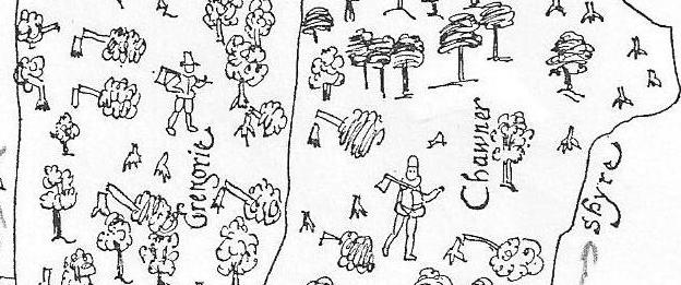
Chawner and Gregorie are probably felling the trees in Tilstock Park in order to see them off and make some money as they change the use of the park from something which would have derived its income from a variety of sources, for example from the deer and other animals kept in the park, from the fish in the ponds and from the sale of wood. The park would now become an open space used as farmland, in this case pasture for sheep or cows.

Armed with the knowledge the original map was kept in the Shropshire Archives in Shrewsbury, I went to see why it hadn’t been reproduced in the book and why Rowley had made a copy. When I saw the original, I quickly understood why. The map was in several shades of green with black ink illustrations on top. This meant it was very difficult to read, and even more difficult to photograph.

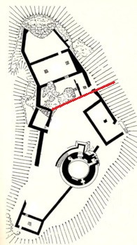
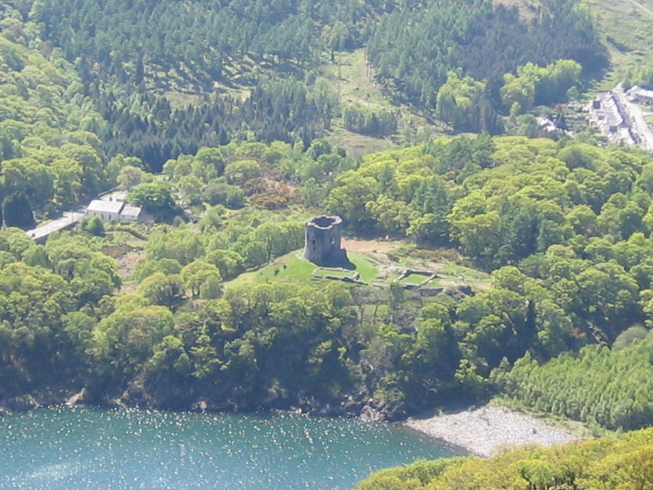
So, what does Tilstock Park look like today?

Tilstock Park Today
Tilstock Park Today in the wider landscape.

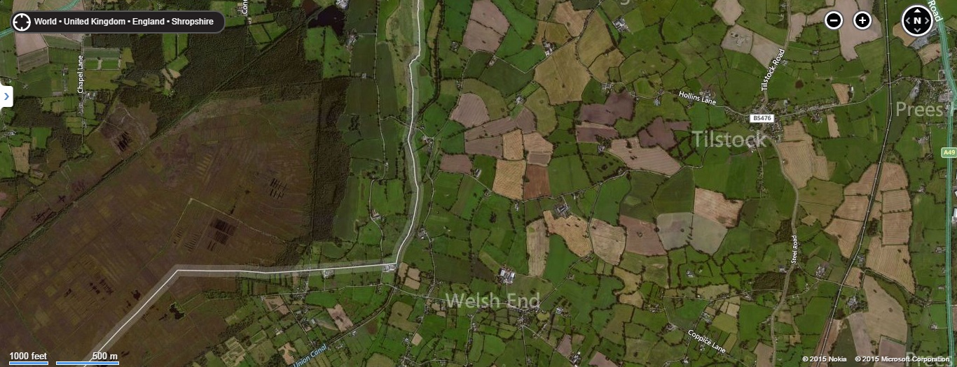
The most obvious feature visible in the park from the air is the site of the former fish ponds.

Tilstock Park Today. The edge of the former fish ponds is highlighted in blue
Tilstock Park Today. The edge of the former fish ponds is highlighted in blue.

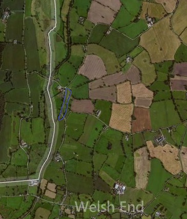
The boundaries of the park are also clearly visible, and next week we’ll look inside the park in greater detail to see what else can be identified in the archaeological record.

Uncategorized

Way out in the Country

My Manchester Metropolitan University page: http://www2.mmu.ac.uk/hpp/research/current-phd-students/

Please help fund my research: http://www.gofundme.com/medievalgardensandparks – just over 50% funded to date.

My Academia.edu page: http://mmu.academia.edu/SpencerGavinSmith

This week I’m looking at the wider world around Dolbadarn Castle (Latitude 53.116526; Longitude -4.114234) after spending the last three weeks in these blog posts:

https://medievalparksgardensanddesignedlandscapes.wordpress.com/2014/12/21/lector-si-monumentum-requiris-circumspice/

https://medievalparksgardensanddesignedlandscapes.wordpress.com/2014/12/30/facial-recognition/

https://medievalparksgardensanddesignedlandscapes.wordpress.com/2015/01/18/the-lady-of-wales-and-her-secret-garden/

looking at the ‘male’ and ‘female’ sides of the structure and architecture. But how does this structure relate to the wider world in which it was constructed? The answer interestingly, has been staring everyone in the face since the very beginning. Llanberis as a village saw little growth in the post-medieval period until two separate factors, the Industrial Revolution and the tourist trade changed the perception of the landscape and to a greater and a lesser extent respectively the landscape itself. The former need not detain us here, but the latter is important in terms of how visitors to this part of Snowdonia interacted with their surroundings.

After the first pioneering tourists in the 1770s came the landscape painters. After the landscape painters, some of whom exhibited in places where their work was viewed by the British upper classes, came Royalty. They wanted, it seems, to see what all the fuss was about in this part of the country. Queen Victoria arrived in 1832. To honour her visit there was a Royal Victoria Hotel, a Victoria Terrace, a Pont Victoria ‘Victoria Bridge’ and a plantation of trees named ‘Coed Victoria’ – Victoria’s Trees. The hotel was constructed in the early nineteenth century to cater for the burgeoning tourist trade and was extended in late nineteenth century.

'Parc Bach' on the 1st edition O.S. map to the west of Dolbadarn Castle. 'Parc Bach' is Welsh for Little Park.
‘Parc Bach’ on the 1st edition O.S. map to the west of Dolbadarn Castle. ‘Parc Bach’ is Welsh for Little Park.

On the 1st edition Ordnance Survey map – dated 1888 – in addition to the panoply of ‘Victoria’ names there is an area to the west of the castle called ‘Parc Bach’, in English ‘Little Park’. The name ‘Parc Bach’ represents a survival of the Welsh royal landscape and provides an additional piece of evidence for the sophistication of Llywelyn and Joan’s castle.

A little, or inner park was a park which was constructed in close proximity to a high-status residence from the twelfth century onwards. A little park could serve a variety of purposes, but was principally designed to serve as a backdrop to the buildings, and could also serve as a venue for staged events or entertainments. A window in the western gable end of the Joan’s hall would allow a view into the park, and an examples of this type of arrangement are known from Woodstock (Oxfordshire) and Windsor (Berkshire).

All the evidence presented in the last four blog posts has been recovered without the use of archaeological excavation and by using evidence derived from the maps, fieldwork and the visible architecture and I hope it has provided you with food for thought. In the next blog post we’ll be on the other side of my study area in Shropshire, looking at an early seventeenth century map and what it can tell us.

Uncategorized

The Lady of Wales and her Secret Garden

My Manchester Metropolitan University page: http://www2.mmu.ac.uk/hpp/research/current-phd-students/

Please help fund my research: http://www.gofundme.com/medievalgardensandparks – just over 50% funded to date.

My Academia.edu page: http://mmu.academia.edu/SpencerGavinSmith

During the previous two blog posts https://medievalparksgardensanddesignedlandscapes.wordpress.com/2014/12/21/lector-si-monumentum-requiris-circumspice/ and https://medievalparksgardensanddesignedlandscapes.wordpress.com/2014/12/30/facial-recognition/ I discussed the ‘male’ side of Dolbadarn Castle (Latitude 53.116526; Longitude -4.114234) and how that masculinity was articulated in the architecture of the building. This week, I want to look at the ‘female’ side of the castle and how that too is reflected in the architecture. The area of the castle I want to discuss is above the red line drawn on the plan of Dolbadarn Castle reproduced below:

Plan of Dolbadarn Castle, area to be discussed is above the red line/.
Plan of Dolbadarn Castle, area to be discussed is above the red line.

The place and power of his Llywelyn’s wife, Joan – known as the ‘Lady of Wales’ – has been noted by historians, particularly Dr Danna Messer (http://independent.academia.edu/DannaMesser) in her recent PhD “The Uxorial Lifecycle and Female Agency in Wales in the Twelfth and Thirteenth Centuries”. Joan was a vitally important part of Llywelyn’s world, and her accommodation and social arrangements in and around the ‘female side’ of the castle are just as sophisticated as the ‘male’ side.

The entrance to Dolbadarn Castle is on the eastern side over looking Padarn Lake, now difficult to access because of the Ministry of Works post and wire face. Once the castle doorkeeper (someone who is mentioned in the Welsh law books) had granted access, then a visitor to Joan or her retinue would have turned right and passed through the fore-building attached to the castle curtain wall to arrive at the entrance to her hall.

Historians have commented previously on the fact that the Welsh law book specific to the Kingdom of Gwynedd in the thirteenth century contains a considerably expanded number of staff for the queen. The queen in this instance is Joan, although no work had been undertaken to attempt to place her and her staff into any of the castle accommodation which would have existed and is visible in the archaeological record. This hall was excavated during the repair and restoration of Dolbadarn Castle in the 1940s, and unfortunately there are no records of any archaeology which was recovered during this work. Understanding how the hall was used through archaeological means does become more difficult, however there are other methods which can be utilised. Although the hall was excavated, the areas to the north and south were not disturbed. By examining these areas, there may be opportunities to understand the relationship the hall had to these areas and the castle as a whole.

Dolbadarn Castle from the opposite side of Padarn Lake.

Beyond the hall is a triangular space which has not previously been discussed in any great detail. This space, walled in and separated from the rest of the castle by the hall, would appear to have served as a garden for Joan when she was in residence. A garden could be created prior to the arrival of the Queen and her household, and an example of this is the garden at Tintagel Castle (Longitude 50.668936; Latitude -4.761529) in Cornwall.

Tintagel Castle garden is the large rectangular structure in the middle of the picture

This garden would have consisted of potted plants which were put into the garden space. The advantage was that these plants could be moved with the female household. In terms of archaeological evidence, this can limit remains to broken and discarded plant pots or if the archaeologists are more fortunate, environmental evidence may be found.

In the next post, I’ll look at how all these elements around Dolbadarn Castle form one sophisticated and complex royal landscape.

Uncategorized

A Real Sense of Power…

The process of writing this PhD has brought with it a feeling of wonder. How, as I’ve rediscovered lost sites and changed people’s perception of previously identified ones, that they were all already there in the landscape that we all use for our own lives, and that we can pass by them every day without giving them a second thought.

A couple of weeks ago there was a post on a group on Facebook highlighting an excellent resource of the National Library of Scotland. http://maps.nls.uk/os/ has a series of searchable Ordnance Survey maps which date – depending on where you live – from 1842 to 1961. Now, in case you haven’t realised by now, I love maps and mapping, and dove straight in to wallow in all this digitised loveliness.

The first place I looked at was, as I am sure many of you also do when you pick up a map, was my home town. In case you are new to the blog, I’m from Wrexham in North East Wales (Latitude 53.045083; Longitude -2.9931521). I selected the earliest map available http://maps.nls.uk/view/102341204 and opened it up.

A few months ago I gave a lecture at the University of Worcester to the archaeology undergraduates, and one of the questions I was asked was ‘How do you know you can see a park in the landscape if it’s not marked as one?’ It’s a difficult question to answer because, as with everyone who has had training in a specialism, sometimes you just ‘know’. However, this piece of map work might explain the methodology a little more clearly.

This is the image that appeared when I opened the map:

Denbighshire Sheet XXVIII Surveyed: 1872 Published: 1879
Denbighshire Sheet XXVIII
Surveyed: 1872
Published: 1879

Parkland – or rather – private parkland around high status houses is shaded in a mid-grey colour, and the town of Wrexham can be seen on the right hand side of the map.

Detail of Denbighshire Sheet XXVIII Surveyed: 1872 Published: 1879
Detail of Denbighshire Sheet XXVIII
Surveyed: 1872
Published: 1879

This parkland is an estate known as Plas Power (‘Plas’ is the Welsh word for Palace or high status house). Although it isn’t very far from where I was brought up, I have to confess I didn’t know very much about it. The parkland is surrounded by high walls and it is still a private estate. The church is accessible, situated outside the parkland, but inside those walls is one of those locations which has been perpetually off limits. I was aware that Plas Power, the house itself, had been demolished in after World War II and there were photographs of the building which has been taken prior to this.

Plas Power Hall prior to demolition

When I’d opened the map originally I’d spotted a darker colour oval shape within the Plas Power parkland (if you want to go back to the original map at this point you might be able to see this) and to me, that oval seemed to be very similar in size and shape to the deer park enclosure at Eyton which has a long and well attested history and which I’ve previously blogged about here: https://medievalparksgardensanddesignedlandscapes.wordpress.com/2013/05/19/making-the-familiar-unfamiliar/

Detail of Denbighshire Sheet XXVIII Surveyed: 1872 Published: 1879
Detail of Denbighshire Sheet XXVIII
Surveyed: 1872
Published: 1879
Detail of Denbighshire Sheet XXXV Surveyed: 1872 to 1873 Published: 1879
Detail of Denbighshire Sheet XXXV
Surveyed: 1872 to 1873
Published: 1879

A full site visit will have to wait for the owners permission, but I was able to use the ‘Clywedog Trail’ http://www.wrexham.gov.uk/english/leisure_tourism/clywedog_trail.htm to access a viewpoint to the south of the site which allowed me the opportunity to take a picture of the southern boundary of the site.

Southern Edge of the Plas Power Enclosure

What is immediately visible from the photograph is that the western boundary has a very steep edge. This would fit with keeping deer within an enclosure of this type, and in addition the LiDAR (Light Detection And Ranging) data http://www.english-heritage.org.uk/professional/research/landscapes-and-areas/aerial-survey/archaeology/lidar/ appears to back up my hypothesis. This identification of this enclosure is excellent news, because it means there is another early enclosure which I can compare directly others previously recognised.

Finally, I’d like to thank everyone for their support. The message I sent via Twitter two weeks ago is still being re-tweeted and has raised another £25 towards my course fees. If you think you can help, please visit http://www.gofundme.com/medievalgardensandparks

Uncategorized

From Psychiatrists to Peter Rabbit

My apologies for not putting up a blog post in quite a while, so I hope you will read this one in its entirety, and if you think someone else should read it, please pass it on.

On the 6th of December 2013 I was at work when I suffered what can best be described as the mother and father of depressive panic attacks. It really frightened me and thinking of the consequences of what I might do to myself in this mood, I drove myself straight to my Doctor’s Surgery and asked to see someone. The receptionist was really patient with me, especially after she told me there was no Dr. available to see me and I pointed out I wasn’t leaving, because I was scared of walking away from a situation where I would receive help.

The Dr. who saw me took one look at me, asked me a couple of questions and immediately phoned to make me an appointment with the mental health team at one of the major hospitals. I was taken there and after a brief conversation with a nurse was put in a quiet ‘special’ room to wait for a full assessment. The room had very heavy furniture with rounded edges and no easy way to get your fingers underneath to lift any of it up. The windows were bolted shut, the pictures screwed to the wall and a panic button fitted behind where the assessor was to sit. I suppose people had been there in far angrier moods than me.

The assessment was an opportunity to talk. I was allowed to ramble on, follow tangents and let everything tumble out of my mouth in an unfocussed narrative. Much is written about how writing a PhD can be detrimental to your mental health, but not much is written about when a PhD is the glue that binds your mental health together. I have a good life, as many people do who suffer mental health issues, but when that indefinable something gets in under your skin and the tiny problems you are experiencing start to expand and fill your every thought. Well, you get the picture.

I’ve been ill before, and I mean physically ill. I’ve had a couple of operations on my kidneys and my gall bladder out. Add to that some other scars from various other adventures and I have parts of my skin that look like a dog chew toy. Physical pain I can handle, junior doctors at the end of my bed staring at my testicles I can handle, but letting someone look inside your head is a very different experience indeed. In one sense, writing these blog posts are letting people inside my head, by explaining the inner workings of how I come to work out various concepts and points of my thesis. In another sense, many of you don’t know me as a person and form your opinions of me from what I write on here, and my writing has meant that my first term was funded by you, and I in turn am inspired by your faith in me.

After the assessment by a psychiatrist I was allowed home and this was the start of my recovery. In order to recover from something like this you have to admit that you understand that there are problems, and that you need to address each one as an individual rather than screw them up into one big ball which is then juggled around as one big worry. Making sure I fulfilled my obligations to you, the people who support me by reading the blog and contributing to my PhD fee payment fund http://www.gofundme.com/medievalgardensandparks is something which I have to admit worried me and was rolled up in my big ball.

Thanks to the dispassionate honesty of my psychiatrist, the love of my family and the support of three friends in particular – you know who you are – I’ve been able to work through my problems and I’m now well enough, both physically and mentally, to be able to continue with the writing process and to able to talk about my latest discovery, which all starts with the ‘The Tale of Peter Rabbit’ http://en.wikipedia.org/wiki/The_Tale_of_Peter_Rabbit by Beatrix Potter.

One of my friends has just given birth, and she and her husband have decorated the nursery. They chose to put up illustrations from ‘The Tale of Peter Rabbit’. I remembered that the illustrations were drawn in the garden of Gwaynynog Hall near Denbigh (Latitude 53.177178; Longitude -3.445713) and so posted a link to the BBC News article http://news.bbc.co.uk/1/hi/wales/north_east/4441615.stm to show her.

Galch Hill

And then I thought. Hang on a minute. Where exactly is Gwaynynog Hall? So, I checked my maps and it lies within one of Denbigh’s medieval parks. Which then made me think that Peter Rabbit, or at least the rabbits that Beatrix Potter was inspired by when she created Peter Rabbit, arrived in the area during the medieval period. Whether these were imported by English or Welsh royalty is a little bit more difficult to establish without archaeological excavation of the medieval rabbit warren locations, but it is an important step forward in understanding the landscape. And I’ll be sure to tell my friends’s newborn daughter someday how she helped me start writing again.

If anything in the first part of this blog post struck a chord, you could try the following websites:

http://www.mind.org.uk

http://bemindful.co.uk

Uncategorized

Patterns in the Palimpsest

Many of my friends and colleagues have found themselves confronted with tweets, facebook messages or e-mails which usually consist of: “I’VE FOUND ANOTHER PARK!”

Whilst the response from my fellow academics is usually “Excellent!”, those not so familiar with this kind of landscape research tend to ask “How?”. So, in this blog post I thought I’d explain some of the methods used to find and identify a park as medieval and then attempt to place it in its context.

Cambridge University Library has one of five known sets of proof maps prepared for John Speed’s ‘Theatre of the Empire of Great Britaine’, which was published in 1611/12, and they are available to view online at: http://www.lib.cam.ac.uk/deptserv/maps/speed.html

Below is an extract taken from the map of Denbighshire showing the area around Wrexham, North East Wales (Latitude 53.045083; Longitude -2.9931521).

Abenbury

As you can see, there are two parks marked on the map, one of them ‘Holt Park’, but the second has no information provided for its location other than it is to the east of Wrexham. At this time the castle at Holt and its attendant town were the most important focal point for the administration of the area, whist Wrexham was a town in all but name (Wrexham was awarded its borough charter in 1857, whilst the borough of Holt was dissolved in 1886). My blog post on the excavations at Holt Castle can be found here: https://medievalparksgardensanddesignedlandscapes.wordpress.com/2013/07/26/the-boss-with-apologies-to-bruce-springsteen/

Whilst the medieval landscape of Holt has seen some academic research, the history of the park to the east of Wrexham is a little more enigmatic. The map shows that it has a very straight western boundary, and this equates to the very straight edge of the park known today as Cefn Park.

Cefn Park Map

Map of Cefn Park

Cefn Park AP

Aerial Photograph of Cefn Park

The Park is now divided into two separate estates, known as Cefn Park and Llwyn Onn. The majority of the papers relating to the estates were either lost in a fire in the house of Cefn Park, and those that do survive only extend back to the Eighteenth Century. All three depictions of Cefn Park show it as an being roughly oval in shape. This is usually an indicator that a park was laid out in the medieval period, but is it possible to be more precise with a date?

At the Marford bailiwick court held on 5 October 1333 the jurors referred back to the time when Roger de Kettley, chief forester, ‘took all the wood of Glyn, which was previously common, into a fenced enclosure for the lord’. The ‘wood of Glyn’ is now the part of the park around the National Trust property of Erddig Hall http://www.nationaltrust.org.uk/erddig/

This suggests then that a new park was required by the English Lord of Bromfield and Yale at Glyn, which is close to the former motte and bailey castle of ‘Wristleham’ (Wrexham), recorded as being in existence in 1161. This, along with a new park laid out at Holt (and recorded on the John Speed map) indicates a considerable reorganisation of the landscape.

The question therefore, is where is Cefn Park in the records of the period? The Extant of Bromfield and Yale, taken in 1315 for the new English Lord describing who owed what service to the him after he had replaced the Welsh Prince following the Edwardian Conquest of 1282-1283, appears to contain the answer.

Cefn Park is in Abenbury, and the ‘Extent’ records that it is held by Griffi ap Ior, Griff ap Hwfa, Ienna ap Hwfa and Griff ap Ior Fychan (‘ap’ is son of, Fychan is ‘little’ or ‘junior’), except one-fifth which is held from the Queen (the wife of Edward II).

These men, and their ancestors, appear to have held the land in return for carrying out services including supplying grain, gathering nuts and making and repairing some of the buildings required by the lordship administrators. All of these services needed land, and it appear then that Cefn Park was no longer a hunting park of the Princes of Powys, but had been ‘disparked’ and put to use supplying these resources.

It kept its western boundary as this was the division between it and the pasture owned by the Abbey at Valle Crucis, which they had been gifted in 1202 and the charter for which still survives.

How much older than 1202 then is Cefn Park? At the moment I’ve exhausted the sources available to me, so I suspect that archaeological excavation of the park, either its boundaries or any identifiable internal features may provide the answer.

Uncategorized

Archaeological Arrogance?

The A55 expressway across North Wales passes many archaeological and historical sites. Many of them are preserved and respected, either by national bodies or in private ownership. Occasionally they are compromised by the whims of succeeding generations, for example the later road and rail bridges around Conwy Castle, but on the whole those which were deemed of sufficient importance were protected by legislation of one form or another.

One site I am writing about in my PhD thesis has disappeared from the landscape. I pass its former location twice a day as I drive from my house to the office and look up at the jagged hole in the skyline which was once the site of an Iron Age Hillfort.

This jagged hole was created because the solid geology which made up the Hillfort was Limestone, and the Limestone was needed to provide the flux in the blast furnaces for making steel at the nearby steelworks in Shotton, but what of the archaeological and historical significance of this site being removed lorry load by lorry load?

The most recent name for this site is Dinorben (Latitude 53.265522; Longitude -3.545362). The voracious appetite of the steelworks saw an intermittent programme of archaeological excavations from 1912 to 1978, with the result that the understanding of the archaeological context of the Hillfort is now well understood through various publications.

Or is it?

This Hillfort has previous, both archaeological and historical, which has been neglected in the drive to tell one story over another. In 1334, the Hillfort was recorded in ‘The Survey of the Honour of Denbigh’. This is one of the extents which I mentioned in a previous blog post (https://medievalparksgardensanddesignedlandscapes.wordpress.com/2013/06/23/si-longtemps-et-merci-pour-le-poisson/) and which were compiled in the Fourteenth century describing who owed what service to the ‘new’ English Lord of the Manor – who had replaced the Welsh Prince after the Edwardian Conquest of 1282-1283.

The Hillfort is known as ‘Pendinas’ (Top of the City) and is described as a wood of nearly five acres, covered with poor scrub and in the possession of Johannes of Rhuddlan. Whilst ‘Pendinas’ may have been the official name, by the time the archaeologists arrived in the early Twentieth century it was known as ‘Parc y Meirch’ (The Horse Park). The Hillfort defences were reused during the medieval period as the location of a horse stud, and if the horses were ill, then they could avail themselves of a holy well, dedicated to St. Siôr, titular saint of horses.

This narrative however, merited only the briefest of mentions in the archaeological reports produced on the site, and the archaeologists changed the name of the site from ‘Parc y Meirch’ to ‘Dinorben’ – the name of a land division. Quite why the archaeologists felt the need to change the name I’ve yet to fully decipher, but it appears that medieval name and story was known by the archaeologists, but it did not fit with the story they wished to tell.

To compound the issue further the medieval finds, consisting of horse shoes and pottery, were confined to an appendix of the main site report written in the late 1960s and early 1970s. The reason for this confinement may be because the principal archaeologist was a prehistorian, and again, the story was not the one which needed to be told.

Parc y Meirch is a very important site in terms of understanding how a medieval horse stud related to the wider landscape within my PhD study area. The side lining of one interpretation over another because it does not fit your personal archaeological aims can never help the overall understanding of a monument in a landscape, and ensuring that archaeological and historical evidence is presented in a balanced manner will always advance the archaeological agenda, even if you don’t agree with the findings, or even the name of the place you are excavating.

Uncategorized

Making the Familiar, Unfamiliar

Academic disciplines move at different speeds. So a piece of information that may be common knowledge to one group may be completely unknown to another. In this case, ignorance really isn’t bliss.

To illustrate my point, here’s one a thousand years (or so) in the making.

Eyton (Latitude 52.991226; Longitude -2.968168) is an area to the south of Wrexham. The name, which means “Island Settlement”, is applied to a village, and also to several buildings including ‘Eaton Hall’ and ‘Eaton Grange’, as well as to landscape features including ‘Eyton Bank’ and ‘Park Eyton’. You will have noticed that in the case of ‘Park Eyton’, the words are reversed. This is because it should be ‘Parc Eyton’, and therefore, is in the Welsh, not the English language.

Why? Well, let’s start with a date nearly everybody knows. 1066. William the Conqueror arrives from France and before you know it is King of England (this blog isn’t about the minutiae of that topic – you can read those elsewhere). The Welsh, well, to be honest, they didn’t really notice. Their Chroniclers are still dealing with the fallout from the death of Gruffydd ap Llywelyn “King of the Britons” who had been assassinated three years previously.

During Christmas 1085, William commissioned a survey of the land he held and of the people living on it. Originally it was known as the Winchester Roll / the King’s Roll or the Book of the Treasury, but by 1180 it was known as the Domesday Book.

The western edge of William’s land holdings was, to be honest, a little blurry. Wales, certainly in the North, had not been ‘conquered’. A little singed and plundered, yes. But not conquered. At the time the Surveyor’s for the roll / book passed through, some places were under new control, and Eyton provides an excellent example. The entry covers Trevalyn, Eyton and Sutton Green. This is an area approximately 14km (8 miles) long and 5km (3 miles) wide. Importantly for my research the Surveyor’s list 2 ‘enclosures’ or ‘hays’. The full entry can be found here http://www.domesdaymap.co.uk/place/SJ4148/sutton/ and explains what it all means at the same time.

The Surveyor’s role was to record items of value, so an enclosure for the capture and control of deer (which is what a ‘hay’ is) would have been recorded. Just because of where it is in Wales doesn’t necessarily mean the invading Normans or the previous neighbours next door, the Anglo – Saxons, built it.

So. The medieval historians are aware of a deer enclosure in Eyton. Are any other academic disciplines like to have encountered it? Well, yes. The academics studying medieval Welsh poetry were aware of two poems by different authors mentioning ‘Eytun’ http://www.dafyddapgwilym.net – Poem 154 is by the very famous and very, very funny Dafydd ap Gwilym and is one of the examples.

Documents survived from 1269 and 1270 discussing who the park belonged to and how it should be divided up on the death of its owner. Parish historians had identified that Parc Eyton was a distinct landholding during their research into the Tithe Maps (a map of a parish or township, prepared following the Tithe Commutation Act 1836. This act allowed tithes to be paid in cash rather than goods. The map and its accompanying schedule gave the names of all owners and occupiers of land in the parish) produced in the early 19th century.

First archaeological record of Parc Eyton? 2004. http://www.coflein.gov.uk/en/site/308744/details/PARK+EYTON%2C+PARK%2C+RUABON/

First Map of Parc Eyton which shows the original boundaries and suggests how large the landholding eventually became? Last Week. I made it.

942879_10151356971290997_249957180_n