Uncategorized

Way out in the Country

My Manchester Metropolitan University page: http://www2.mmu.ac.uk/hpp/research/current-phd-students/

Please help fund my research: http://www.gofundme.com/medievalgardensandparks – just over 50% funded to date.

My Academia.edu page: http://mmu.academia.edu/SpencerGavinSmith

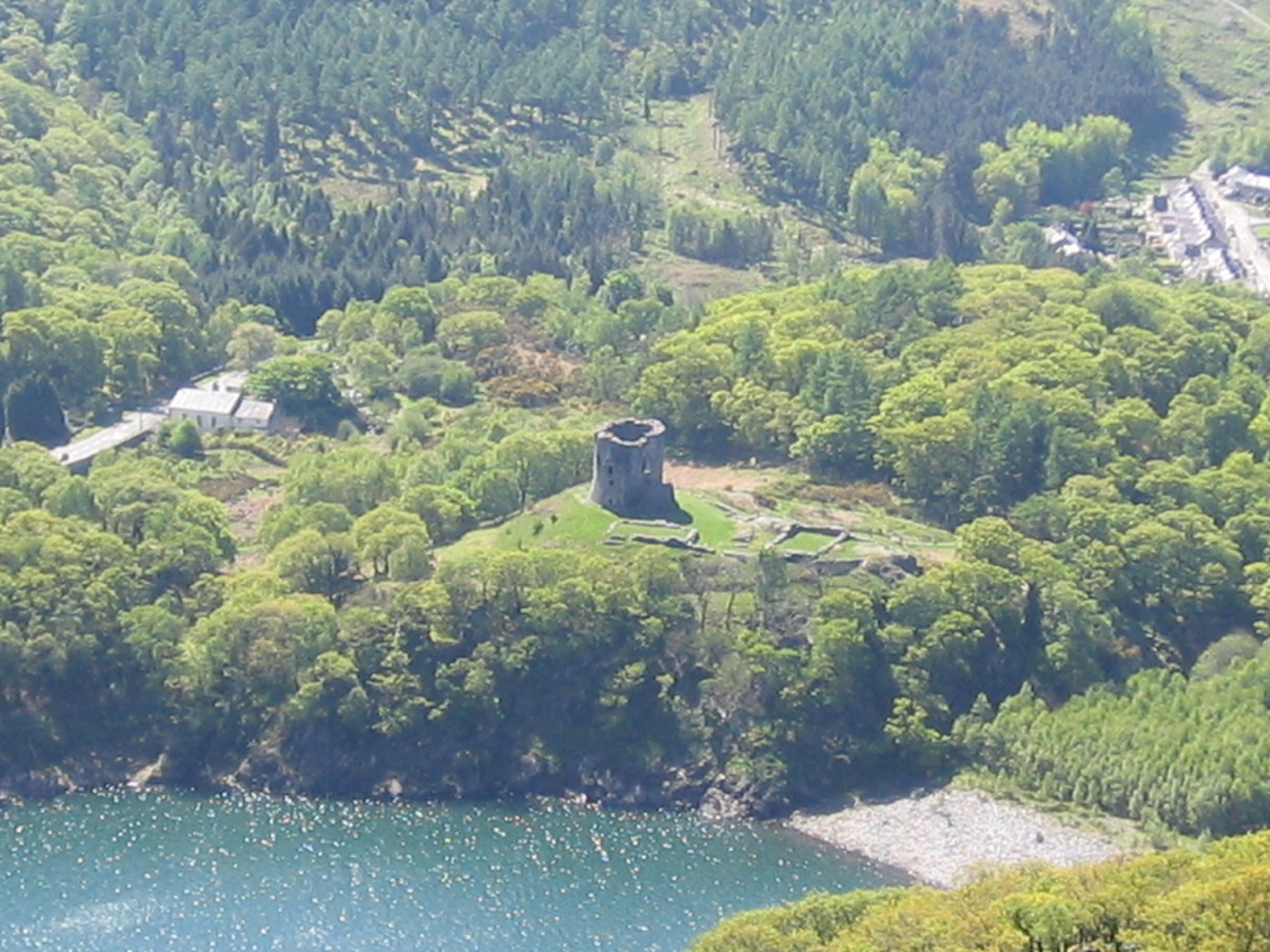
This week I’m looking at the wider world around Dolbadarn Castle (Latitude 53.116526; Longitude -4.114234) after spending the last three weeks in these blog posts:

https://medievalparksgardensanddesignedlandscapes.wordpress.com/2014/12/21/lector-si-monumentum-requiris-circumspice/

https://medievalparksgardensanddesignedlandscapes.wordpress.com/2014/12/30/facial-recognition/

https://medievalparksgardensanddesignedlandscapes.wordpress.com/2015/01/18/the-lady-of-wales-and-her-secret-garden/

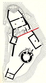
looking at the ‘male’ and ‘female’ sides of the structure and architecture. But how does this structure relate to the wider world in which it was constructed? The answer interestingly, has been staring everyone in the face since the very beginning. Llanberis as a village saw little growth in the post-medieval period until two separate factors, the Industrial Revolution and the tourist trade changed the perception of the landscape and to a greater and a lesser extent respectively the landscape itself. The former need not detain us here, but the latter is important in terms of how visitors to this part of Snowdonia interacted with their surroundings.

After the first pioneering tourists in the 1770s came the landscape painters. After the landscape painters, some of whom exhibited in places where their work was viewed by the British upper classes, came Royalty. They wanted, it seems, to see what all the fuss was about in this part of the country. Queen Victoria arrived in 1832. To honour her visit there was a Royal Victoria Hotel, a Victoria Terrace, a Pont Victoria ‘Victoria Bridge’ and a plantation of trees named ‘Coed Victoria’ – Victoria’s Trees. The hotel was constructed in the early nineteenth century to cater for the burgeoning tourist trade and was extended in late nineteenth century.

'Parc Bach' on the 1st edition O.S. map to the west of Dolbadarn Castle. 'Parc Bach' is Welsh for Little Park.
‘Parc Bach’ on the 1st edition O.S. map to the west of Dolbadarn Castle. ‘Parc Bach’ is Welsh for Little Park.

On the 1st edition Ordnance Survey map – dated 1888 – in addition to the panoply of ‘Victoria’ names there is an area to the west of the castle called ‘Parc Bach’, in English ‘Little Park’. The name ‘Parc Bach’ represents a survival of the Welsh royal landscape and provides an additional piece of evidence for the sophistication of Llywelyn and Joan’s castle.

A little, or inner park was a park which was constructed in close proximity to a high-status residence from the twelfth century onwards. A little park could serve a variety of purposes, but was principally designed to serve as a backdrop to the buildings, and could also serve as a venue for staged events or entertainments. A window in the western gable end of the Joan’s hall would allow a view into the park, and an examples of this type of arrangement are known from Woodstock (Oxfordshire) and Windsor (Berkshire).

All the evidence presented in the last four blog posts has been recovered without the use of archaeological excavation and by using evidence derived from the maps, fieldwork and the visible architecture and I hope it has provided you with food for thought. In the next blog post we’ll be on the other side of my study area in Shropshire, looking at an early seventeenth century map and what it can tell us.

Uncategorized

The Lady of Wales and her Secret Garden

My Manchester Metropolitan University page: http://www2.mmu.ac.uk/hpp/research/current-phd-students/

Please help fund my research: http://www.gofundme.com/medievalgardensandparks – just over 50% funded to date.

My Academia.edu page: http://mmu.academia.edu/SpencerGavinSmith

During the previous two blog posts https://medievalparksgardensanddesignedlandscapes.wordpress.com/2014/12/21/lector-si-monumentum-requiris-circumspice/ and https://medievalparksgardensanddesignedlandscapes.wordpress.com/2014/12/30/facial-recognition/ I discussed the ‘male’ side of Dolbadarn Castle (Latitude 53.116526; Longitude -4.114234) and how that masculinity was articulated in the architecture of the building. This week, I want to look at the ‘female’ side of the castle and how that too is reflected in the architecture. The area of the castle I want to discuss is above the red line drawn on the plan of Dolbadarn Castle reproduced below:

Plan of Dolbadarn Castle, area to be discussed is above the red line/.
Plan of Dolbadarn Castle, area to be discussed is above the red line.

The place and power of his Llywelyn’s wife, Joan – known as the ‘Lady of Wales’ – has been noted by historians, particularly Dr Danna Messer (http://independent.academia.edu/DannaMesser) in her recent PhD “The Uxorial Lifecycle and Female Agency in Wales in the Twelfth and Thirteenth Centuries”. Joan was a vitally important part of Llywelyn’s world, and her accommodation and social arrangements in and around the ‘female side’ of the castle are just as sophisticated as the ‘male’ side.

The entrance to Dolbadarn Castle is on the eastern side over looking Padarn Lake, now difficult to access because of the Ministry of Works post and wire face. Once the castle doorkeeper (someone who is mentioned in the Welsh law books) had granted access, then a visitor to Joan or her retinue would have turned right and passed through the fore-building attached to the castle curtain wall to arrive at the entrance to her hall.

Historians have commented previously on the fact that the Welsh law book specific to the Kingdom of Gwynedd in the thirteenth century contains a considerably expanded number of staff for the queen. The queen in this instance is Joan, although no work had been undertaken to attempt to place her and her staff into any of the castle accommodation which would have existed and is visible in the archaeological record. This hall was excavated during the repair and restoration of Dolbadarn Castle in the 1940s, and unfortunately there are no records of any archaeology which was recovered during this work. Understanding how the hall was used through archaeological means does become more difficult, however there are other methods which can be utilised. Although the hall was excavated, the areas to the north and south were not disturbed. By examining these areas, there may be opportunities to understand the relationship the hall had to these areas and the castle as a whole.

Dolbadarn Castle from the opposite side of Padarn Lake.

Beyond the hall is a triangular space which has not previously been discussed in any great detail. This space, walled in and separated from the rest of the castle by the hall, would appear to have served as a garden for Joan when she was in residence. A garden could be created prior to the arrival of the Queen and her household, and an example of this is the garden at Tintagel Castle (Longitude 50.668936; Latitude -4.761529) in Cornwall.

Tintagel Castle garden is the large rectangular structure in the middle of the picture

This garden would have consisted of potted plants which were put into the garden space. The advantage was that these plants could be moved with the female household. In terms of archaeological evidence, this can limit remains to broken and discarded plant pots or if the archaeologists are more fortunate, environmental evidence may be found.

In the next post, I’ll look at how all these elements around Dolbadarn Castle form one sophisticated and complex royal landscape.