Archaeology, Cymru, Europe, Ewrop, History, Uncategorized, Wales

New Shoots and Tree Roots

Apologies for the lack of activity. I have been chronically unwell (again). That, coupled with the shear volume of material I had collected, and unfortunately also curated, meant I felt I had nothing constructive to offer by the way of a blog post. Finally however, my last operation – hopefully for a while at least – will be on the 22nd of April 2016, so I expect to be able to write happily unencumbered by the usual ever growing rock army of kidney stones.

In among all this internal excitement I have also moved house. We (my wife and our three cats) now live in the flat which used to belong to my paternal grandparents. Built in the 1970s, it is light, bright and airy and most importantly my desk is now by a big window rather than tucked away in the far corner of the last place we lived.

As part of the moving in process I decided I would re-establish the container garden my grandfather maintained, and pots and soil in hand I planted up some heather and lavender and replanted my wife’s strawberry plant. As I stood and admired my handy work from the kitchen window, arm deep in washing up suds, I decided I would work on the material for my PhD chapter on gardens. It is by far the weakest chapter in terms of content and structure, but the strongest in terms of the new discoveries I have made during the research process. Unfortunately, many of these ideas have gone straight into the lecturing notes and Power Point presentations, rather than into the chapter as they should have.

Last summer I was fortunate enough to be one of two archaeologists working on an archaeological excavation in Rhuddlan (Latitude 53.288595; Longitude -3.463749). I’ve blogged about Rhuddlan previously, see:

https://medievalparksgardensanddesignedlandscapes.wordpress.com/2013/08/11/our-dark-garden/

and

https://medievalparksgardensanddesignedlandscapes.wordpress.com/2014/06/01/the-medieval-magic-in-pit-t349/

for some context to the area of North Wales I’m talking about.

The excavation was undertaken for a client who had planning permission to build a new house within a medieval burgage plot directly opposite the north-west corner of the Edwardian castle [A burgage was a town rental property owned by a king or lord. The burgage usually, and distinctly, consisted of a house on a long and narrow plot of land with a narrow street frontage]. A preceding archaeological evaluation, which examined only a small percentage of the total area of the site found medieval and post-medieval pottery and hints of some kind of ditch system within the plot.

Documentary research established that the front of the burgage plot was now lost under part of a row of nineteenth century cottages, but the rear of the plot, as far as all the evidence indicated had been unencumbered by buildings and appeared to have always served as a garden in one form or another. My fellow archaeologist and I employed the services of a mechanical excavator to remove the considerable overburden dumped on the plot from the building of both the cottages at the front of the plot but also from the construction of another row of nineteenth century cottages to the western side of the plot.

The archaeological excavation of the medieval deposits revealed that the rear of the plot had not been occupied by a property, but had served as open space within which over the following centuries a series of pits and ditches had been dug, some of which had animal bone within them. However it was something far more ephemeral which was uncovered that I was more excited about for my PhD research.

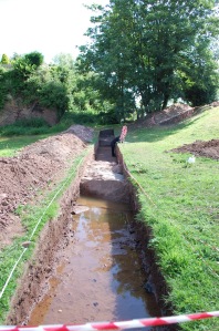
The natural ground surface (that is the surface into which we find cut the earliest archaeological deposits on any site) was on one part of the site imprinted with the ends of tree roots. This was where a tree had established itself within the soil higher up than the natural and had then tried to extend its tree roots through the natural. In this case, the natural was a very hard and impermeable clay, meaning the tree roots left ‘dents’ as it tried to force its way into the ground.

Tree Roots Not Marked
The site post excavation (after all excavation had been completed). Rhuddlan Edwardian Castle is at the top of the picture. Scale 1x1m.
Tree Roots Marked
The indentations within the red circle are those left by the tree roots as they tried to push through the natural clay.

Why are tree root indentations exciting? The Edwardian castle garden was only 80 metres (262 feet) away and planted on identical geology. Although all above ground evidence, except for the well within the garden has disappeared, the excavations reveal the kind of archaeological evidence we should expect if an excavation on the site of the Edwardian Castle garden was undertaken. And I haven’t given up on the idea that I could be the person to lead and carry out that excavation.

FURTHER INFORMATION:

My Manchester Metropolitan University page – which describes the aims and objectives of my PhD research:

http://www2.mmu.ac.uk/hpp/research/current-phd-students/

You can also help fund my research – which has reached its original funding target. However if you like what you read, then you can still donate.

http://www.gofundme.com/medievalgardensandparks

My Academia.edu page – where you can download my published research:

http://mmu.academia.edu/SpencerGavinSmith


Uncategorized

Way out in the Country

My Manchester Metropolitan University page: http://www2.mmu.ac.uk/hpp/research/current-phd-students/

Please help fund my research: http://www.gofundme.com/medievalgardensandparks – just over 50% funded to date.

My Academia.edu page: http://mmu.academia.edu/SpencerGavinSmith
This week I’m looking at the wider world around Dolbadarn Castle (Latitude 53.116526; Longitude -4.114234) after spending the last three weeks in these blog posts:

https://medievalparksgardensanddesignedlandscapes.wordpress.com/2014/12/21/lector-si-monumentum-requiris-circumspice/

https://medievalparksgardensanddesignedlandscapes.wordpress.com/2014/12/30/facial-recognition/

https://medievalparksgardensanddesignedlandscapes.wordpress.com/2015/01/18/the-lady-of-wales-and-her-secret-garden/

looking at the ‘male’ and ‘female’ sides of the structure and architecture. But how does this structure relate to the wider world in which it was constructed? The answer interestingly, has been staring everyone in the face since the very beginning. Llanberis as a village saw little growth in the post-medieval period until two separate factors, the Industrial Revolution and the tourist trade changed the perception of the landscape and to a greater and a lesser extent respectively the landscape itself. The former need not detain us here, but the latter is important in terms of how visitors to this part of Snowdonia interacted with their surroundings.

After the first pioneering tourists in the 1770s came the landscape painters. After the landscape painters, some of whom exhibited in places where their work was viewed by the British upper classes, came Royalty. They wanted, it seems, to see what all the fuss was about in this part of the country. Queen Victoria arrived in 1832. To honour her visit there was a Royal Victoria Hotel, a Victoria Terrace, a Pont Victoria ‘Victoria Bridge’ and a plantation of trees named ‘Coed Victoria’ – Victoria’s Trees. The hotel was constructed in the early nineteenth century to cater for the burgeoning tourist trade and was extended in late nineteenth century.

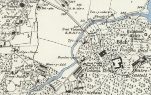
'Parc Bach' on the 1st edition O.S. map to the west of Dolbadarn Castle. 'Parc Bach' is Welsh for Little Park.
‘Parc Bach’ on the 1st edition O.S. map to the west of Dolbadarn Castle. ‘Parc Bach’ is Welsh for Little Park.

On the 1st edition Ordnance Survey map – dated 1888 – in addition to the panoply of ‘Victoria’ names there is an area to the west of the castle called ‘Parc Bach’, in English ‘Little Park’. The name ‘Parc Bach’ represents a survival of the Welsh royal landscape and provides an additional piece of evidence for the sophistication of Llywelyn and Joan’s castle.

A little, or inner park was a park which was constructed in close proximity to a high-status residence from the twelfth century onwards. A little park could serve a variety of purposes, but was principally designed to serve as a backdrop to the buildings, and could also serve as a venue for staged events or entertainments. A window in the western gable end of the Joan’s hall would allow a view into the park, and an examples of this type of arrangement are known from Woodstock (Oxfordshire) and Windsor (Berkshire).

All the evidence presented in the last four blog posts has been recovered without the use of archaeological excavation and by using evidence derived from the maps, fieldwork and the visible architecture and I hope it has provided you with food for thought. In the next blog post we’ll be on the other side of my study area in Shropshire, looking at an early seventeenth century map and what it can tell us.

Uncategorized

Tell me about it, stud.

The medieval horse.

Most people when they see those words tend to have something like this in mind.

Copyright THoog
Copyright THoog

A knight and his similarly armoured stallion.

But how often did the stallion end up in all his armour? And what did he do on his day off? Which sounds ridiculous, but is a valid point.

Most of the time he would have being doing this:

3765021094_f47dba227b_z

Or making foals…but you don’t need a picture of that…

Part of my research is looking for the evidence for the medieval horse studs – The word “stud” comes from the Old English ‘stod’ meaning “herd of horses, place where horses are kept for breeding” – within my study area of North Wales and North West Shropshire. There are several sources of evidence that I’ve been using and I thought I’d discuss them this week.

Firstly, there is the archaeological evidence – and this can be divided into the skeletal evidence for the horses themselves and the evidence for their horse ‘furniture’, pieces like reins, saddles and horseshoes. Skeletal evidence is, unfortunately, a bit thin on the ground, and where it does exist, for example at Aldford Castle in Cheshire (Longitude:53.130188; Latitude:-2.870270) it was very badly ‘smashed’ – that is to say, it was in pieces big enough to know it was a horse, but too small to be able to estimate the size of the horse.

I’ve previously discussed the loss of the site of Parc-y-Meirch (The Horse Park) in the blog post https://medievalparksgardensanddesignedlandscapes.wordpress.com/2013/07/08/archaeological-arrogance/ but fortunately during the rescue excavations medieval horseshoes were recovered from the site – which helped corroborate the second strand of evidence I want to discuss – the historical evidence.

Again, it is possible to divide the historical evidence into two sections, that is evidence for specific sites – such as the evidence from ‘The Survey of the Honour of Denbigh’ taken in 1334 which lists Parc-y-Meirch. The other section is the historical evidence which is non-site specific. An example of this can be found in the writings of Giraldus Cambrensis / Gerald of Wales:

“There are some excellent stud-farms. A superb race of blood-stock is now bred there, tracing its descent from the Spanish horses which Robert de Bellême, Earl of Shrewsbury, had gone to some pains to have imported long ago. The horses which are sent out from Powys are greatly prized: they are extremely handsome and nature reproduces in them the same majestic proportions and incomparable speed.”

Welsh poetry of the medieval period can also help understand the breeding programme. The poet Cynddelw Brydydd Mawr described Madog ap Maredudd (Prince of Powys from 1132-1160) as a ‘companion of Gascon horses’ and the poet Llywarch ap Llywelyn says that Llywelyn ap Iorwerth (Prince of Gwynedd 1195-1240) had Gascon horses. Gascony is in south west France (Longitude:43.763138; Latitude:-0.046619), so the importation of the horses appears to have gone on for at least a century.

Finally there is the pictorial evidence for horses in the Welsh Law Books – in Peniarth MS.28 on folio 24v there is a picture of a horse within the section of the law on horses:

mrw 090

So, as you can see from this small selection of sources, the study of horses and where they were kept and bred is full of variety and I’m really enjoying the research to find out more.

Uncategorized

My Story: Why I’m blogging about my Research

For those of you new to the blog I thought I’d recap the who / what / where / when / why and how I write something every Sunday and post it on the Internet, with links through to some of my previous posts and other related pages.

My name is Spencer Gavin Smith, and I’m from the town of Wrexham in North East Wales (Latitude 53.045083; Longitude -2.9931521) and I’m writing my PhD on the topic of ‘Parks, Gardens and Designed Landscapes of Medieval North Wales and North West Shropshire’ part-time at Manchester Metropolitan University.

This is me.
This is me.

I began this research back as an undergraduate in 1997: https://medievalparksgardensanddesignedlandscapes.wordpress.com/2013/04/28/to-begin-at-the-beginning-or-has-anyone-seen-that-confounded-bridge/ and was fortunate to receive the support of Dr. Enid Roberts – one of the specialists in the field, at a lecture I gave in 2003 https://medievalparksgardensanddesignedlandscapes.wordpress.com/2013/05/02/standing-on-the-toes-of-giants/ – and had a Rock and Roll legend in the audience to boot!

My research covers the disciplines of archaeology, history, literature and the visual arts. I’m trying to identify through these sources of evidence, the creation and use of medieval parks, gardens and designed landscapes of Medieval North Wales and North West Shropshire. This topic has not been covered in any great detail previously, with https://medievalparksgardensanddesignedlandscapes.wordpress.com/2013/06/23/si-longtemps-et-merci-pour-le-poisson/ and https://medievalparksgardensanddesignedlandscapes.wordpress.com/2013/07/21/an-attempt-to-buck-the-trend/ giving you some idea of the cutting edge research I’m undertaking.

Even though this research is cutting edge https://medievalparksgardensanddesignedlandscapes.wordpress.com/2013/07/14/please-fund-my-cutting-edge-phd-research/ I’ve had problems convincing charities and other organisations to fund it because it is multidisciplinary. I wrote to 123 charities, and not one them felt able to fund me – some didn’t even bother to reply to me.

I consequently set up a Crowd Funding page at: http://www.gofundme.com/medievalgardensandparks and thanks to the kindness of strangers and one or two friends they provided enough funding in the space of a month to cover my first terms fees https://medievalparksgardensanddesignedlandscapes.wordpress.com/2013/08/18/taking-stock/

I’m now enrolled at University https://medievalparksgardensanddesignedlandscapes.wordpress.com/2013/10/13/enroled-thank-you-so-much-lets-keep-the-adventure-going/ under the academic care of a supervisor I have a great deal of personal and professional respect for and the writing is going really well https://medievalparksgardensanddesignedlandscapes.wordpress.com/2013/08/26/patterns-in-the-palimpsest/ and https://medievalparksgardensanddesignedlandscapes.wordpress.com/2013/09/15/shropshire-and-everything-after/ give you some idea of this.

I’m still looking for funding – and here is what’s in it for you.

· I’ll include your name in my PhD acknowledgements.
· Answer any questions you have about what I’m writing about.
· Give you a real or virtual tour of any of the sites I’m writing about.
· I’ll give a real or virtual talk about my research to a group of people you think would be interested.
· If I get a book deal when I’ve finished the PhD, I’ll put your name in the acknowledgements.
· If I get a book deal when I’ve finished the PhD, the person who provides the greatest amount of funding will receive a free signed copy of the finished book.

Thank you and I hope you enjoy the blog.

Uncategorized

Interviewed for the Radio and Chapter 1 Draft handed in…

Two sides of my academic coin this week.

I regularly contribute to BBC Radio Cymru (Welsh language service) and BBC Radio Wales (English Language service) programmes. Usually it is to provide expert comment on an archaeological story which is in the news, and that has some kind of Welsh perspective or angle. This week, however, was a little bit special as on BBC Radio Cymru on Thursday morning I got to comment on a story which has a family connection.

DSC03640

My great-great Uncle was Edward John Smith – Captain of the RMS Titanic.

http://www.bbc.co.uk/news/uk-wales-17513240

In 2012 I was fortunate to be asked to contribute to several news items, and a programme for the Welsh language television broadcaster S4C on the Welsh people connected to the story of the famous steamship.

This week, one of the most iconic items connected with the events of the 15th of April 1912 was auctioned after its provenance had been authenticated. The item was the violin played by RMS Titanic bandleader Wallace Hartley as the ship sank with the loss of 1,517 lives, including Hartley’s and my Great-Great-Uncle.

http://www.bbc.co.uk/news/uk-england-wiltshire-24582739

The violin sold for £900,000.

Personally, I find it comforting that Captain Smith may just have heard this instrument being played that night, and that a tangible archaeological artifact floated rather than sank, safe in its protective cocoon and strapped to its owner, who unfortunately did not survive the experience.

This week I also collected my University identification card.

DSC03650edit

Which makes it all official really doesn’t it?

To that end, Chapter 1 has gone off to my Supervisor for her to cast her expert eye over it…let’s see what polishing and preening, nipping and tucking, and padding and fleshing my draft requires.

Uncategorized

Our Dark Garden

With due deference to everyone who has tweeted, retweeted, donated or sent best wishes to me and my quest for PhD funding, I thought that this blog post should talk about some of the medieval gardens I’ve been researching, and the variety of sources available for such a study.

The earliest contemporary written evidence for the creation of gardens in Wales is to be found in the biography of a twelfth century king, Gruffydd ap Cynan, of the Welsh kingdom of Gwynedd. The Historia Gruffud vab Kenan says:

‘Then he increased all manner of good in Gwynedd, and the inhabitants began to build churches in every direction therein, and to plant the old woods and to make orchards and gardens, and surround them with walls and ditches, and to construct walled buildings, and to support themselves from the fruit of the earth after the fashion of the Romans’.

Some evidence for this reorganisation and improvement of Gwynedd has been identified, most recently by David Longley, and his research into the medieval landscape of the island of Anglesey. However, there are problems which mean that further work is still needed.

Archaeological excavations of medieval high status sites in Wales have tended to be small in scale, and to date very few high-status Llys (Royal Court) sites have been excavated. Exacerbating this is the fact that only some of the Llys site locations are known, as they fell out of use during the fourteenth century because they were no longer needed by the new administration.

The Edwardian castle at Rhuddlan (Latitude 53.288595; Longitude -3.463749) serves to highlight some of the issues which I have encountered during my research.

This castle was constructed from 1277 onwards to replace an earlier motte and bailey castle on a nearby site to the south, which in turn replaced a Llys, the location of which is most probably under the motte and bailey earthworks.

DI2010_1781

Crown Copyright DI2010_1781
The motte and bailey castle is in the trees to the right of the image.

Edward I, as part of the provision for his wife, Eleanor of Castile, and her household, had constructed for her a garden within the castle precinct between July 1282 and March 1284. The location for this has been suggested as within the inner courtyard of the castle, where it would have been overlooked by the Royal apartments.

The documentation states that encircling the head of the castle well (which had a boarded roof), a little fishpond lined with four cartloads of clay brought from the nearby Rhuddlan marsh was created and set around with seats. The adjacent courtyard was laid with 6000 turves and the lawn fenced with the staves of discarded casks.

Rhuddlan Castle was taken into state care in the twentieth century and following World War II conservation works were carried out. As part of the conservation works the moat was emptied:

DI2010_2242

Crown Copyright DI2010_2242
Excavation of the moat in 1949.

Unfortunately I have not been able to find any archaeological documentation to accompany the photographs taken, meaning any environmental evidence, including medieval plants, which may have existed within the moat has now been lost. In addition, there has been no programme of survey or excavation within the inner courtyard of castle, meaning that the location of the garden and fishpond is not conclusively identified.

During my research, I re-examined the historical sources, and found mention of a second garden at Rhuddlan Castle in 1285. This was described as a herber (a pleasure garden) opposite the north gate of the castle, and significantly, outside of the castle precinct. Fieldwork I undertook earlier this year suggests that this herber lay within the ditch to the north of the castle and may well have been accessible from the River Clwyd immediately to the west. The location of the herber is at the bottom left of the first photograph under the trees.

Further research of sites such as the Edwardian Castle of Rhuddlan will revolve around planning the best recording strategies for these two garden locations, whether that is deemed to be survey or excavation. Given that there is in close proximity an earlier motte and bailey and a Llys site, both of which are likely to have gardens of one form or another associated with them, there is exceptional potential for understanding the change and development of Royal gardening taste of both English and Welsh Royalty during the medieval period.

Uncategorized

Park it like you stole from it…

The blog is a day later than usual – but that because the story of this current blog post has only just come to an end.

I had a day off last Monday, and I used it to visit two archaeological exacavations happening 10 minutes away from where I live. Both are on prehistoric hillforts, and both are fascinating.

I’ll confess now to a previous life as a prehistorian – I spent 4 years at Bournemouth University as part of the ‘Billown Neolithic Landscape Project’ on the Isle of Man. I learnt so much about looking at, and interpreting a landscape without documents – which can be a bit like looking for medieval deer parks in North Wales – relying on the palimpest of landscape features to guide your thought process.

The excavations at Moel y Gaer, Bodfari (Latitude 53.226804; Longitude -3.357079) by the University of Oxford: http://www.arch.ox.ac.uk/bodfari.html and Penycloddiau (Latitude 53.198650; Longitude -3.306009) by the University of Liverpool: http://www.liv.ac.uk/sace/resource/LAFS_report_2012.htm are excellent examples of where archaeologists working in different disciplines can assist each other in interpreting a site.

I’m interested whether the prehistoric hillforts found themselves an afterlife as animal enclosures in the medieval period, see my blog post: https://medievalparksgardensanddesignedlandscapes.wordpress.com/2013/07/08/archaeological-arrogance/ for the re-use of Parc-y-Meirch / Dinorben as a medieval horse park.

So far I have at least three hillforts where I can attest their re-use, either from historical or archaeological sources.

By the same token, the prehistorians are interested in what happened to their sites after they went out of use as hillforts. It’s early days in understanding the later use of Penycloddiau and Moel-y-Gaer, Bodfari, but the archaeologists could not have been more helpful.

While this was happening, my crowdfunding PhD page was attracting the attention of the media. The Daily Post, a newspaper which covers North Wales ran this story: http://www.dailypost.co.uk/news/local-news/archaeologist-crowd-sourcing-donation-internet-5378330 and the BBC ran this story: http://www.bbc.co.uk/news/uk-wales-north-west-wales-23458968 about my discovery of a medieval deer park at Brynkir (Latitude 52.967469; Longitude -4.197846) (but unfortunately left out my name as the finder)…

Thanks to the generosity of the media in running the story, the funders who have made sure I’ve already made it to 1/8th of my required total: http://www.gofundme.com/medievalgardensandparks and fellow archaeologists for allowing me to visit their excavations I’ve enjoyed a positive week – with the final part coming at 7:55 this morning when I was interviewed on BBC Radio Cymru (the Welsh Language radio station) about the work at Brynkir Medieval park.

Let’s see what happens next.

Uncategorized

The Boss (with apologies to Bruce Springsteen)

Today I had the opportunity to visit the archaeological excavations being undertaken at Holt Castle (Longitude 53.077958; Latitude -2.880319). Of the Lordship castles constructed in north east Wales after the Edwardian Conquest of 1282, Holt is the most incomplete structurally, but has arguably the most fascinating story.

Holt Castle was constructed by the Lord of the new Lordship Bromfield and Yale, William Warenne, to replace the burnt out and partially demolished shell of Castell Dinas Bran. This castle had been constructed by Gruffydd ap Madog for his Principality of Powys Fadog.

Essentially – the Edwardian Conquest saw a redrawing of the administrative boundaries, with the new Lordships replacing the old Principality, and a Welsh Prince replaced by an English Lord.

William Warenne decided he need a new castle from which to run his new lordship, and decided (although we don’t know how he came to this decision) that a site on the bank of the River Dee and close to the English Border was the most suitable. There he had the masons in his employ quarry away the sandstone river bank to create a boss of rock, on which the central block of the castle was built.

DSC_4125crop

The central boss of rock on and around which Holt Castle was built

The boss of rock was five sided, and an outer wall was constructed parallel to it. Which as the photograph shows has now gone, robbed out to construct Samwell Hall, the predecessor of the current Eaton Hall in Cheshire.

DSC_4128crop

The remains of one of one of the bases of the outer wall towers visible in the centre of the trench

The excavations are a fantastic example of how organisations, in this case:
Cadw http://cadw.wales.gov.uk/
Northern Marches Cymru http://www.northernmarchescymru.co.uk/
Wrexham County Borough Council http://wrexham.gov.uk/
and
Holt Local History Society http://holtlhs.weebly.com/index.html

can all work in partnership in order to bring this monument back to life – and as today was the ‘Day of Archaeology’, I couldn’t imagine a more apt example to highlight what archaeology is all about.

Uncategorized

Archaeological Arrogance?

The A55 expressway across North Wales passes many archaeological and historical sites. Many of them are preserved and respected, either by national bodies or in private ownership. Occasionally they are compromised by the whims of succeeding generations, for example the later road and rail bridges around Conwy Castle, but on the whole those which were deemed of sufficient importance were protected by legislation of one form or another.

One site I am writing about in my PhD thesis has disappeared from the landscape. I pass its former location twice a day as I drive from my house to the office and look up at the jagged hole in the skyline which was once the site of an Iron Age Hillfort.

This jagged hole was created because the solid geology which made up the Hillfort was Limestone, and the Limestone was needed to provide the flux in the blast furnaces for making steel at the nearby steelworks in Shotton, but what of the archaeological and historical significance of this site being removed lorry load by lorry load?

The most recent name for this site is Dinorben (Latitude 53.265522; Longitude -3.545362). The voracious appetite of the steelworks saw an intermittent programme of archaeological excavations from 1912 to 1978, with the result that the understanding of the archaeological context of the Hillfort is now well understood through various publications.

Or is it?

This Hillfort has previous, both archaeological and historical, which has been neglected in the drive to tell one story over another. In 1334, the Hillfort was recorded in ‘The Survey of the Honour of Denbigh’. This is one of the extents which I mentioned in a previous blog post (https://medievalparksgardensanddesignedlandscapes.wordpress.com/2013/06/23/si-longtemps-et-merci-pour-le-poisson/) and which were compiled in the Fourteenth century describing who owed what service to the ‘new’ English Lord of the Manor – who had replaced the Welsh Prince after the Edwardian Conquest of 1282-1283.

The Hillfort is known as ‘Pendinas’ (Top of the City) and is described as a wood of nearly five acres, covered with poor scrub and in the possession of Johannes of Rhuddlan. Whilst ‘Pendinas’ may have been the official name, by the time the archaeologists arrived in the early Twentieth century it was known as ‘Parc y Meirch’ (The Horse Park). The Hillfort defences were reused during the medieval period as the location of a horse stud, and if the horses were ill, then they could avail themselves of a holy well, dedicated to St. Siôr, titular saint of horses.

This narrative however, merited only the briefest of mentions in the archaeological reports produced on the site, and the archaeologists changed the name of the site from ‘Parc y Meirch’ to ‘Dinorben’ – the name of a land division. Quite why the archaeologists felt the need to change the name I’ve yet to fully decipher, but it appears that medieval name and story was known by the archaeologists, but it did not fit with the story they wished to tell.

To compound the issue further the medieval finds, consisting of horse shoes and pottery, were confined to an appendix of the main site report written in the late 1960s and early 1970s. The reason for this confinement may be because the principal archaeologist was a prehistorian, and again, the story was not the one which needed to be told.

Parc y Meirch is a very important site in terms of understanding how a medieval horse stud related to the wider landscape within my PhD study area. The side lining of one interpretation over another because it does not fit your personal archaeological aims can never help the overall understanding of a monument in a landscape, and ensuring that archaeological and historical evidence is presented in a balanced manner will always advance the archaeological agenda, even if you don’t agree with the findings, or even the name of the place you are excavating.

Uncategorized

Hand Axis

Archaeology – and matters related to it, have been in the news this week. With the death of Mick Aston, we have lost someone who knew how to communicate his passion for several layers of informative dirt piled on top of each other to the public, in a way they found engaging and interesting.

Mick was part of a team, and we should remember that many of us in the profession have been involved with at least one show during its long run in one capacity or another. We, and the watching public are all part of that team and must continue to keep archaeology in the minds of the public, in whatever form it may take.

Announced in the Government Spending Review was that £80 million pounds will be provided by the Government to establish a charity to care for the historic properties in the National Heritage Collection of English Heritage on a self-financing basis http://www.english-heritage.org.uk/about/news/80million-boost-heritage/.

Also announced was £100 billion pounds to be spent on infrastructure improvements http://www.bbc.co.uk/news/uk-politics-23080965 including upgrades to the A14, a new Mersey Gateway Bridge and the first stages of work on the HS2 rail link.

By association, some of this money will have to be spent on the archaeology effected by these announcements. We should embrace the opportunity to do justice to whatever is found, whichever archaeological units secures the contracts.

At the same time as the commercial units will be opening up swathes of countryside in advance of the road and rail building programmes, or working with the new charity to better interpret the properties in their care, Heritage Lottery Funded archaeological projects will be opening their own smaller, but no less important holes in their towns and villages.

Answering specific research questions and aided by professional archaeologists, these focused pieces of work will in essence, fill gaps which the commercial units will never be able to reach. http://www.hlf.org.uk/HowToApply/whatwefund/Pages/Archaeology.aspx.

Publicising the findings, whether through personal Twitter accounts, newspaper articles or television programmes, we must demonstrate that this money was well spent and increased our knowledge of the island palimpsest we live on.