Archaeology, Cymru, Europe, Ewrop, History, Uncategorized, Wales

New Shoots and Tree Roots

Apologies for the lack of activity. I have been chronically unwell (again). That, coupled with the shear volume of material I had collected, and unfortunately also curated, meant I felt I had nothing constructive to offer by the way of a blog post. Finally however, my last operation – hopefully for a while at least – will be on the 22nd of April 2016, so I expect to be able to write happily unencumbered by the usual ever growing rock army of kidney stones.

In among all this internal excitement I have also moved house. We (my wife and our three cats) now live in the flat which used to belong to my paternal grandparents. Built in the 1970s, it is light, bright and airy and most importantly my desk is now by a big window rather than tucked away in the far corner of the last place we lived.

As part of the moving in process I decided I would re-establish the container garden my grandfather maintained, and pots and soil in hand I planted up some heather and lavender and replanted my wife’s strawberry plant. As I stood and admired my handy work from the kitchen window, arm deep in washing up suds, I decided I would work on the material for my PhD chapter on gardens. It is by far the weakest chapter in terms of content and structure, but the strongest in terms of the new discoveries I have made during the research process. Unfortunately, many of these ideas have gone straight into the lecturing notes and Power Point presentations, rather than into the chapter as they should have.

Last summer I was fortunate enough to be one of two archaeologists working on an archaeological excavation in Rhuddlan (Latitude 53.288595; Longitude -3.463749). I’ve blogged about Rhuddlan previously, see:

https://medievalparksgardensanddesignedlandscapes.wordpress.com/2013/08/11/our-dark-garden/

and

https://medievalparksgardensanddesignedlandscapes.wordpress.com/2014/06/01/the-medieval-magic-in-pit-t349/

for some context to the area of North Wales I’m talking about.

The excavation was undertaken for a client who had planning permission to build a new house within a medieval burgage plot directly opposite the north-west corner of the Edwardian castle [A burgage was a town rental property owned by a king or lord. The burgage usually, and distinctly, consisted of a house on a long and narrow plot of land with a narrow street frontage]. A preceding archaeological evaluation, which examined only a small percentage of the total area of the site found medieval and post-medieval pottery and hints of some kind of ditch system within the plot.

Documentary research established that the front of the burgage plot was now lost under part of a row of nineteenth century cottages, but the rear of the plot, as far as all the evidence indicated had been unencumbered by buildings and appeared to have always served as a garden in one form or another. My fellow archaeologist and I employed the services of a mechanical excavator to remove the considerable overburden dumped on the plot from the building of both the cottages at the front of the plot but also from the construction of another row of nineteenth century cottages to the western side of the plot.

The archaeological excavation of the medieval deposits revealed that the rear of the plot had not been occupied by a property, but had served as open space within which over the following centuries a series of pits and ditches had been dug, some of which had animal bone within them. However it was something far more ephemeral which was uncovered that I was more excited about for my PhD research.

The natural ground surface (that is the surface into which we find cut the earliest archaeological deposits on any site) was on one part of the site imprinted with the ends of tree roots. This was where a tree had established itself within the soil higher up than the natural and had then tried to extend its tree roots through the natural. In this case, the natural was a very hard and impermeable clay, meaning the tree roots left ‘dents’ as it tried to force its way into the ground.

Tree Roots Not Marked
The site post excavation (after all excavation had been completed). Rhuddlan Edwardian Castle is at the top of the picture. Scale 1x1m.
Tree Roots Marked
The indentations within the red circle are those left by the tree roots as they tried to push through the natural clay.

Why are tree root indentations exciting? The Edwardian castle garden was only 80 metres (262 feet) away and planted on identical geology. Although all above ground evidence, except for the well within the garden has disappeared, the excavations reveal the kind of archaeological evidence we should expect if an excavation on the site of the Edwardian Castle garden was undertaken. And I haven’t given up on the idea that I could be the person to lead and carry out that excavation.

FURTHER INFORMATION:

My Manchester Metropolitan University page – which describes the aims and objectives of my PhD research:

http://www2.mmu.ac.uk/hpp/research/current-phd-students/

You can also help fund my research – which has reached its original funding target. However if you like what you read, then you can still donate.

http://www.gofundme.com/medievalgardensandparks

My Academia.edu page – where you can download my published research:

http://mmu.academia.edu/SpencerGavinSmith


Uncategorized

The Lady of Wales and her Secret Garden

My Manchester Metropolitan University page: http://www2.mmu.ac.uk/hpp/research/current-phd-students/

Please help fund my research: http://www.gofundme.com/medievalgardensandparks – just over 50% funded to date.

My Academia.edu page: http://mmu.academia.edu/SpencerGavinSmith
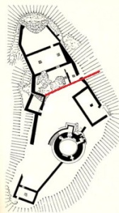
During the previous two blog posts https://medievalparksgardensanddesignedlandscapes.wordpress.com/2014/12/21/lector-si-monumentum-requiris-circumspice/ and https://medievalparksgardensanddesignedlandscapes.wordpress.com/2014/12/30/facial-recognition/ I discussed the ‘male’ side of Dolbadarn Castle (Latitude 53.116526; Longitude -4.114234) and how that masculinity was articulated in the architecture of the building. This week, I want to look at the ‘female’ side of the castle and how that too is reflected in the architecture. The area of the castle I want to discuss is above the red line drawn on the plan of Dolbadarn Castle reproduced below:

Plan of Dolbadarn Castle, area to be discussed is above the red line/.
Plan of Dolbadarn Castle, area to be discussed is above the red line.

The place and power of his Llywelyn’s wife, Joan – known as the ‘Lady of Wales’ – has been noted by historians, particularly Dr Danna Messer (http://independent.academia.edu/DannaMesser) in her recent PhD “The Uxorial Lifecycle and Female Agency in Wales in the Twelfth and Thirteenth Centuries”. Joan was a vitally important part of Llywelyn’s world, and her accommodation and social arrangements in and around the ‘female side’ of the castle are just as sophisticated as the ‘male’ side.

The entrance to Dolbadarn Castle is on the eastern side over looking Padarn Lake, now difficult to access because of the Ministry of Works post and wire face. Once the castle doorkeeper (someone who is mentioned in the Welsh law books) had granted access, then a visitor to Joan or her retinue would have turned right and passed through the fore-building attached to the castle curtain wall to arrive at the entrance to her hall.

Historians have commented previously on the fact that the Welsh law book specific to the Kingdom of Gwynedd in the thirteenth century contains a considerably expanded number of staff for the queen. The queen in this instance is Joan, although no work had been undertaken to attempt to place her and her staff into any of the castle accommodation which would have existed and is visible in the archaeological record. This hall was excavated during the repair and restoration of Dolbadarn Castle in the 1940s, and unfortunately there are no records of any archaeology which was recovered during this work. Understanding how the hall was used through archaeological means does become more difficult, however there are other methods which can be utilised. Although the hall was excavated, the areas to the north and south were not disturbed. By examining these areas, there may be opportunities to understand the relationship the hall had to these areas and the castle as a whole.

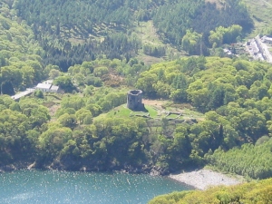
Dolbadarn Castle from the opposite side of Padarn Lake.

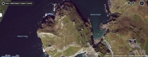
Beyond the hall is a triangular space which has not previously been discussed in any great detail. This space, walled in and separated from the rest of the castle by the hall, would appear to have served as a garden for Joan when she was in residence. A garden could be created prior to the arrival of the Queen and her household, and an example of this is the garden at Tintagel Castle (Longitude 50.668936; Latitude -4.761529) in Cornwall.

Tintagel Castle garden is the large rectangular structure in the middle of the picture

This garden would have consisted of potted plants which were put into the garden space. The advantage was that these plants could be moved with the female household. In terms of archaeological evidence, this can limit remains to broken and discarded plant pots or if the archaeologists are more fortunate, environmental evidence may be found.

In the next post, I’ll look at how all these elements around Dolbadarn Castle form one sophisticated and complex royal landscape.

Uncategorized

My Story: Why I’m blogging about my Research

For those of you new to the blog I thought I’d recap the who / what / where / when / why and how I write something every Sunday and post it on the Internet, with links through to some of my previous posts and other related pages.

My name is Spencer Gavin Smith, and I’m from the town of Wrexham in North East Wales (Latitude 53.045083; Longitude -2.9931521) and I’m writing my PhD on the topic of ‘Parks, Gardens and Designed Landscapes of Medieval North Wales and North West Shropshire’ part-time at Manchester Metropolitan University.

This is me.
This is me.

I began this research back as an undergraduate in 1997: https://medievalparksgardensanddesignedlandscapes.wordpress.com/2013/04/28/to-begin-at-the-beginning-or-has-anyone-seen-that-confounded-bridge/ and was fortunate to receive the support of Dr. Enid Roberts – one of the specialists in the field, at a lecture I gave in 2003 https://medievalparksgardensanddesignedlandscapes.wordpress.com/2013/05/02/standing-on-the-toes-of-giants/ – and had a Rock and Roll legend in the audience to boot!

My research covers the disciplines of archaeology, history, literature and the visual arts. I’m trying to identify through these sources of evidence, the creation and use of medieval parks, gardens and designed landscapes of Medieval North Wales and North West Shropshire. This topic has not been covered in any great detail previously, with https://medievalparksgardensanddesignedlandscapes.wordpress.com/2013/06/23/si-longtemps-et-merci-pour-le-poisson/ and https://medievalparksgardensanddesignedlandscapes.wordpress.com/2013/07/21/an-attempt-to-buck-the-trend/ giving you some idea of the cutting edge research I’m undertaking.

Even though this research is cutting edge https://medievalparksgardensanddesignedlandscapes.wordpress.com/2013/07/14/please-fund-my-cutting-edge-phd-research/ I’ve had problems convincing charities and other organisations to fund it because it is multidisciplinary. I wrote to 123 charities, and not one them felt able to fund me – some didn’t even bother to reply to me.

I consequently set up a Crowd Funding page at: http://www.gofundme.com/medievalgardensandparks and thanks to the kindness of strangers and one or two friends they provided enough funding in the space of a month to cover my first terms fees https://medievalparksgardensanddesignedlandscapes.wordpress.com/2013/08/18/taking-stock/

I’m now enrolled at University https://medievalparksgardensanddesignedlandscapes.wordpress.com/2013/10/13/enroled-thank-you-so-much-lets-keep-the-adventure-going/ under the academic care of a supervisor I have a great deal of personal and professional respect for and the writing is going really well https://medievalparksgardensanddesignedlandscapes.wordpress.com/2013/08/26/patterns-in-the-palimpsest/ and https://medievalparksgardensanddesignedlandscapes.wordpress.com/2013/09/15/shropshire-and-everything-after/ give you some idea of this.

I’m still looking for funding – and here is what’s in it for you.

· I’ll include your name in my PhD acknowledgements.
· Answer any questions you have about what I’m writing about.
· Give you a real or virtual tour of any of the sites I’m writing about.
· I’ll give a real or virtual talk about my research to a group of people you think would be interested.
· If I get a book deal when I’ve finished the PhD, I’ll put your name in the acknowledgements.
· If I get a book deal when I’ve finished the PhD, the person who provides the greatest amount of funding will receive a free signed copy of the finished book.

Thank you and I hope you enjoy the blog.

Uncategorized

Interviewed for the Radio and Chapter 1 Draft handed in…

Two sides of my academic coin this week.

I regularly contribute to BBC Radio Cymru (Welsh language service) and BBC Radio Wales (English Language service) programmes. Usually it is to provide expert comment on an archaeological story which is in the news, and that has some kind of Welsh perspective or angle. This week, however, was a little bit special as on BBC Radio Cymru on Thursday morning I got to comment on a story which has a family connection.

DSC03640

My great-great Uncle was Edward John Smith – Captain of the RMS Titanic.

http://www.bbc.co.uk/news/uk-wales-17513240

In 2012 I was fortunate to be asked to contribute to several news items, and a programme for the Welsh language television broadcaster S4C on the Welsh people connected to the story of the famous steamship.

This week, one of the most iconic items connected with the events of the 15th of April 1912 was auctioned after its provenance had been authenticated. The item was the violin played by RMS Titanic bandleader Wallace Hartley as the ship sank with the loss of 1,517 lives, including Hartley’s and my Great-Great-Uncle.

http://www.bbc.co.uk/news/uk-england-wiltshire-24582739

The violin sold for £900,000.

Personally, I find it comforting that Captain Smith may just have heard this instrument being played that night, and that a tangible archaeological artifact floated rather than sank, safe in its protective cocoon and strapped to its owner, who unfortunately did not survive the experience.

This week I also collected my University identification card.

DSC03650edit

Which makes it all official really doesn’t it?

To that end, Chapter 1 has gone off to my Supervisor for her to cast her expert eye over it…let’s see what polishing and preening, nipping and tucking, and padding and fleshing my draft requires.

Uncategorized

Enroled…Thank you so much! Let’s keep the adventure going…

So now I’m back in the fold of the academic community.

MMU_Logo

And I wouldn’t be here with the help of the online community of people who may never have met me, but have read my posts on this blog and felt able to contribute to funding my research.

Am I nervous about restarting? Yes. But, having been able to keep a toe in academia through attending conferences and seeing material published in books and journals whilst I have been a little bit out of the loop is very comforting.

Time I feel to provide a comprehensive update of what I am writing about and why it needs to be done.

My PhD will consist of four chapters when completed. These will be:

1. Introduction to the topic and previous research undertaken.

2. Parks

3. Gardens

4. Temporary and Permanent Designed Landscapes

In addition to these, there is a Bibliography and a Gazetteer – created so each landscape component can be entered onto either a regional or national archaeological database.

Some of the people mentioned in the research will be be very familiar to you. The ‘big’ names like Owain Glyn Dŵr or Edward I make an appearance, but not as the leader of a rebellion, or as ‘The Hammer of the Scots’, but rather as men who created landscapes to enjoy with their families and utilise for economic gain.

I’m also writing about men like Reginald Balle, who lived in the village of Hope in north east Wales (Longitude: 53.118235; Latitude: -3.0328984) during the middle of the fourteenth century and how he profited from the creation of a brand new park just outside the village. And the numerous un-named servants who for 15 days in May, for at least a century and probably much longer, would have to climb trees to capture fledgling sparrowhawks in Pennant Lliw, near Llanuwchllyn in central north Wales (Longitude: 52.876692; Latitude: -3.744210).

aerialphoto

You may have visited some the places I’m writing about, for example Conwy castle (Longitude: 53.280082; Latitude: -3.825695) on the shore of the Conwy Estuary and the River Gyffin. Others, however are a bit further off the beaten track, like Hornspike on the Wales-England border Longitude: 52.903693; Latitude: -2.775291).

This research needs to be done for the simple reason that it has never been done before in a complete way. This research pulls together information from many different sources in three different languages and helps archaeologists, historians and literature specialists all work together to look at this area of the country.

So, please, if you enjoy my blog and would like to help. Either share the link for my blog, or if you are able to contribute then you can do so at: http://www.gofundme.com/medievalgardensandparks

Thank you…and enjoy watching the work unfold here.

Uncategorized

What’s a nice Plaice like you doing in a Girl like this?

There has been much made in the news recently about the rise of the ‘Media Friendly’ Historian or Academic. With their snappy delivery and charismatic persona, they are credited with bringing the past to life for the tech savvy and short attention span generation.

The truth is media friendly historians and academics have always been around, the difference now is that there are far more opportunities to become a star with the proliferation of outlets available. Antiquarians, the fore-runners of today’s modern historians and academics, were just as clever in using the media outlets and resources available to them.

However, there is a group of people who we don’t hear about so often, but whose work we encounter coming out of the mouths of these presenters. We should, as people who are interested in our heritage, be aware of and support them however we can.

The ‘Day of Archaeology’ http://www.dayofarchaeology.com/, founded by Lorna Richardson and Matt Law (@lornarichardson and @m_law on Twitter) highlights the work of the archaeologists, who day in and day out are passionate about what they do. The first ‘Day of Archaeology’ was in July 2011 and the breadth of topics and countries represented on its website is now staggering.

From Zooarchaeologists sifting and sorting their way through boxes of animal bones to tell us more about the community who bred these animals; to Digital Archaeologists creating buildings from archaeological plans, interpreting the post holes or foundation trenches.

Maritime Archaeologists monitor the deterioration of undersea landscapes or wreck sites and decide on conservation strategies and ‘circuit diggers’, the hired guns of the commercial archaeological world, work all over the country in all weathers staying in Bed and Breakfast accommodation and producing high-quality results whilst being too cold to even hold a pencil.

All of these people have a story to tell, and by following the ‘Day of Archaeology’ you can gain an insight into their own personal world and their motivation to record and recover the past for future generations. So next time you watch one of these programmes with its charismatic presenter, remember there is an army of unsung specialists who are quite literally, putting the words in their mouths.

The next ‘Day of Archaeology’ is on Friday 26 July 2013.
You can follow the day through the website http://www.dayofarchaeology.com/
Twitter https://twitter.com/dayofarch
Facebook https://www.facebook.com/thedayofarchaeology?fref=ts

Uncategorized

Making the Familiar, Unfamiliar

Academic disciplines move at different speeds. So a piece of information that may be common knowledge to one group may be completely unknown to another. In this case, ignorance really isn’t bliss.

To illustrate my point, here’s one a thousand years (or so) in the making.

Eyton (Latitude 52.991226; Longitude -2.968168) is an area to the south of Wrexham. The name, which means “Island Settlement”, is applied to a village, and also to several buildings including ‘Eaton Hall’ and ‘Eaton Grange’, as well as to landscape features including ‘Eyton Bank’ and ‘Park Eyton’. You will have noticed that in the case of ‘Park Eyton’, the words are reversed. This is because it should be ‘Parc Eyton’, and therefore, is in the Welsh, not the English language.

Why? Well, let’s start with a date nearly everybody knows. 1066. William the Conqueror arrives from France and before you know it is King of England (this blog isn’t about the minutiae of that topic – you can read those elsewhere). The Welsh, well, to be honest, they didn’t really notice. Their Chroniclers are still dealing with the fallout from the death of Gruffydd ap Llywelyn “King of the Britons” who had been assassinated three years previously.

During Christmas 1085, William commissioned a survey of the land he held and of the people living on it. Originally it was known as the Winchester Roll / the King’s Roll or the Book of the Treasury, but by 1180 it was known as the Domesday Book.

The western edge of William’s land holdings was, to be honest, a little blurry. Wales, certainly in the North, had not been ‘conquered’. A little singed and plundered, yes. But not conquered. At the time the Surveyor’s for the roll / book passed through, some places were under new control, and Eyton provides an excellent example. The entry covers Trevalyn, Eyton and Sutton Green. This is an area approximately 14km (8 miles) long and 5km (3 miles) wide. Importantly for my research the Surveyor’s list 2 ‘enclosures’ or ‘hays’. The full entry can be found here http://www.domesdaymap.co.uk/place/SJ4148/sutton/ and explains what it all means at the same time.

The Surveyor’s role was to record items of value, so an enclosure for the capture and control of deer (which is what a ‘hay’ is) would have been recorded. Just because of where it is in Wales doesn’t necessarily mean the invading Normans or the previous neighbours next door, the Anglo – Saxons, built it.

So. The medieval historians are aware of a deer enclosure in Eyton. Are any other academic disciplines like to have encountered it? Well, yes. The academics studying medieval Welsh poetry were aware of two poems by different authors mentioning ‘Eytun’ http://www.dafyddapgwilym.net – Poem 154 is by the very famous and very, very funny Dafydd ap Gwilym and is one of the examples.

Documents survived from 1269 and 1270 discussing who the park belonged to and how it should be divided up on the death of its owner. Parish historians had identified that Parc Eyton was a distinct landholding during their research into the Tithe Maps (a map of a parish or township, prepared following the Tithe Commutation Act 1836. This act allowed tithes to be paid in cash rather than goods. The map and its accompanying schedule gave the names of all owners and occupiers of land in the parish) produced in the early 19th century.

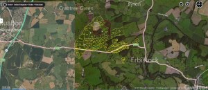
First archaeological record of Parc Eyton? 2004. http://www.coflein.gov.uk/en/site/308744/details/PARK+EYTON%2C+PARK%2C+RUABON/

First Map of Parc Eyton which shows the original boundaries and suggests how large the landholding eventually became? Last Week. I made it.

942879_10151356971290997_249957180_n