Archaeology, Cymru, Europe, Ewrop, History, Uncategorized, Wales

New Shoots and Tree Roots

Apologies for the lack of activity. I have been chronically unwell (again). That, coupled with the shear volume of material I had collected, and unfortunately also curated, meant I felt I had nothing constructive to offer by the way of a blog post. Finally however, my last operation – hopefully for a while at least – will be on the 22nd of April 2016, so I expect to be able to write happily unencumbered by the usual ever growing rock army of kidney stones.

In among all this internal excitement I have also moved house. We (my wife and our three cats) now live in the flat which used to belong to my paternal grandparents. Built in the 1970s, it is light, bright and airy and most importantly my desk is now by a big window rather than tucked away in the far corner of the last place we lived.

As part of the moving in process I decided I would re-establish the container garden my grandfather maintained, and pots and soil in hand I planted up some heather and lavender and replanted my wife’s strawberry plant. As I stood and admired my handy work from the kitchen window, arm deep in washing up suds, I decided I would work on the material for my PhD chapter on gardens. It is by far the weakest chapter in terms of content and structure, but the strongest in terms of the new discoveries I have made during the research process. Unfortunately, many of these ideas have gone straight into the lecturing notes and Power Point presentations, rather than into the chapter as they should have.

Last summer I was fortunate enough to be one of two archaeologists working on an archaeological excavation in Rhuddlan (Latitude 53.288595; Longitude -3.463749). I’ve blogged about Rhuddlan previously, see:

https://medievalparksgardensanddesignedlandscapes.wordpress.com/2013/08/11/our-dark-garden/

and

https://medievalparksgardensanddesignedlandscapes.wordpress.com/2014/06/01/the-medieval-magic-in-pit-t349/

for some context to the area of North Wales I’m talking about.

The excavation was undertaken for a client who had planning permission to build a new house within a medieval burgage plot directly opposite the north-west corner of the Edwardian castle [A burgage was a town rental property owned by a king or lord. The burgage usually, and distinctly, consisted of a house on a long and narrow plot of land with a narrow street frontage]. A preceding archaeological evaluation, which examined only a small percentage of the total area of the site found medieval and post-medieval pottery and hints of some kind of ditch system within the plot.

Documentary research established that the front of the burgage plot was now lost under part of a row of nineteenth century cottages, but the rear of the plot, as far as all the evidence indicated had been unencumbered by buildings and appeared to have always served as a garden in one form or another. My fellow archaeologist and I employed the services of a mechanical excavator to remove the considerable overburden dumped on the plot from the building of both the cottages at the front of the plot but also from the construction of another row of nineteenth century cottages to the western side of the plot.

The archaeological excavation of the medieval deposits revealed that the rear of the plot had not been occupied by a property, but had served as open space within which over the following centuries a series of pits and ditches had been dug, some of which had animal bone within them. However it was something far more ephemeral which was uncovered that I was more excited about for my PhD research.

The natural ground surface (that is the surface into which we find cut the earliest archaeological deposits on any site) was on one part of the site imprinted with the ends of tree roots. This was where a tree had established itself within the soil higher up than the natural and had then tried to extend its tree roots through the natural. In this case, the natural was a very hard and impermeable clay, meaning the tree roots left ‘dents’ as it tried to force its way into the ground.

Tree Roots Not Marked
The site post excavation (after all excavation had been completed). Rhuddlan Edwardian Castle is at the top of the picture. Scale 1x1m.
Tree Roots Marked
The indentations within the red circle are those left by the tree roots as they tried to push through the natural clay.

Why are tree root indentations exciting? The Edwardian castle garden was only 80 metres (262 feet) away and planted on identical geology. Although all above ground evidence, except for the well within the garden has disappeared, the excavations reveal the kind of archaeological evidence we should expect if an excavation on the site of the Edwardian Castle garden was undertaken. And I haven’t given up on the idea that I could be the person to lead and carry out that excavation.

FURTHER INFORMATION:

My Manchester Metropolitan University page – which describes the aims and objectives of my PhD research:

http://www2.mmu.ac.uk/hpp/research/current-phd-students/

You can also help fund my research – which has reached its original funding target. However if you like what you read, then you can still donate.

http://www.gofundme.com/medievalgardensandparks

My Academia.edu page – where you can download my published research:

http://mmu.academia.edu/SpencerGavinSmith


Uncategorized

The Lady of Wales and her Secret Garden

My Manchester Metropolitan University page: http://www2.mmu.ac.uk/hpp/research/current-phd-students/

Please help fund my research: http://www.gofundme.com/medievalgardensandparks – just over 50% funded to date.

My Academia.edu page: http://mmu.academia.edu/SpencerGavinSmith
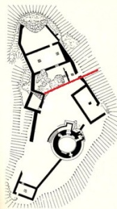
During the previous two blog posts https://medievalparksgardensanddesignedlandscapes.wordpress.com/2014/12/21/lector-si-monumentum-requiris-circumspice/ and https://medievalparksgardensanddesignedlandscapes.wordpress.com/2014/12/30/facial-recognition/ I discussed the ‘male’ side of Dolbadarn Castle (Latitude 53.116526; Longitude -4.114234) and how that masculinity was articulated in the architecture of the building. This week, I want to look at the ‘female’ side of the castle and how that too is reflected in the architecture. The area of the castle I want to discuss is above the red line drawn on the plan of Dolbadarn Castle reproduced below:

Plan of Dolbadarn Castle, area to be discussed is above the red line/.
Plan of Dolbadarn Castle, area to be discussed is above the red line.

The place and power of his Llywelyn’s wife, Joan – known as the ‘Lady of Wales’ – has been noted by historians, particularly Dr Danna Messer (http://independent.academia.edu/DannaMesser) in her recent PhD “The Uxorial Lifecycle and Female Agency in Wales in the Twelfth and Thirteenth Centuries”. Joan was a vitally important part of Llywelyn’s world, and her accommodation and social arrangements in and around the ‘female side’ of the castle are just as sophisticated as the ‘male’ side.

The entrance to Dolbadarn Castle is on the eastern side over looking Padarn Lake, now difficult to access because of the Ministry of Works post and wire face. Once the castle doorkeeper (someone who is mentioned in the Welsh law books) had granted access, then a visitor to Joan or her retinue would have turned right and passed through the fore-building attached to the castle curtain wall to arrive at the entrance to her hall.

Historians have commented previously on the fact that the Welsh law book specific to the Kingdom of Gwynedd in the thirteenth century contains a considerably expanded number of staff for the queen. The queen in this instance is Joan, although no work had been undertaken to attempt to place her and her staff into any of the castle accommodation which would have existed and is visible in the archaeological record. This hall was excavated during the repair and restoration of Dolbadarn Castle in the 1940s, and unfortunately there are no records of any archaeology which was recovered during this work. Understanding how the hall was used through archaeological means does become more difficult, however there are other methods which can be utilised. Although the hall was excavated, the areas to the north and south were not disturbed. By examining these areas, there may be opportunities to understand the relationship the hall had to these areas and the castle as a whole.

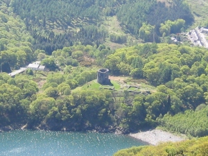
Dolbadarn Castle from the opposite side of Padarn Lake.

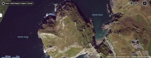
Beyond the hall is a triangular space which has not previously been discussed in any great detail. This space, walled in and separated from the rest of the castle by the hall, would appear to have served as a garden for Joan when she was in residence. A garden could be created prior to the arrival of the Queen and her household, and an example of this is the garden at Tintagel Castle (Longitude 50.668936; Latitude -4.761529) in Cornwall.

Tintagel Castle garden is the large rectangular structure in the middle of the picture

This garden would have consisted of potted plants which were put into the garden space. The advantage was that these plants could be moved with the female household. In terms of archaeological evidence, this can limit remains to broken and discarded plant pots or if the archaeologists are more fortunate, environmental evidence may be found.

In the next post, I’ll look at how all these elements around Dolbadarn Castle form one sophisticated and complex royal landscape.

Uncategorized

Avengers Assemble…but where?

Obliteration.

A very powerful word. It tends to be used to describe the removal of an item from the landscape – and conflict – where ever it may happen, can provide examples of something that was there at one moment only to have ceased to exist in a recognisable form the next.

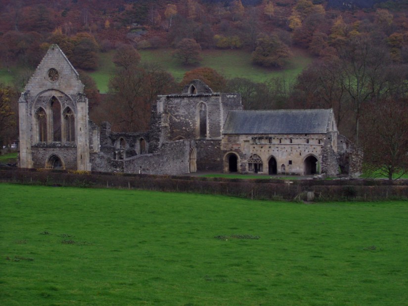
If you visit a medieval site today, with manicured lawns and helpful guidebook, the most obvious thing to notice is that there is actually something left to visit. Even with a tumultuous event like the Dissolution of the Monasteries, where the communities were removed and buildings stripped of useful materials, much of the fabric can have survived the 500 or so years since the event, albeit with piles of fallen masonry removed and a gift shop for all the essential purchases.

Valle Crucis Abbey (Latitude 52.988696; Longitude -3.1868157) http://upload.wikimedia.org/wikipedia/en/1/1e/Valle_Crucis_Abbey.JPG
Valle Crucis Abbey (Latitude 52.988696; Longitude -3.1868157)
http://upload.wikimedia.org/wikipedia/en/1/1e/Valle_Crucis_Abbey.JPG

Sites composed of earthworks, for example motte and bailey castles, can appear at first glance even more ephemeral. Understanding how each individual lump and bump relates to another does take practice, but an understanding of the typology of different monument types means that even these can be interpreted as the visitor walks around the site.

Earthworks of Tomen y Bala Motte and Bailey Castle (Latitude 52.911565; Longitude -3.5954770)

Some sites however, defy simple interpretation if they have been ‘removed’ from the landscape because of their social, political or cultural importance. During the Croat-Bosnian war in 1993, the 16th century Stari Most bridge over the river Neretva in the City of Mostar, Bosnia (Latitude 43.205425; Longitude 17.483822) was destroyed by Croat forces.

Stari Most bridge over the river Neretva in the City of Mostar, Bosnia (Latitude 43.205425; Longitude 17.483822) prior to destruction.
Stari Most bridge over the river Neretva in the City of Mostar, Bosnia (Latitude 43.205425; Longitude 17.483822) prior to completion of the destruction process.

The removal of the bridge had a twofold purpose. Firstly, access from one side of the river by the inhabitants of Mostar to the other was limited, and secondly the Stari Most bridge was considered one of the most important pieces of Islamic architecture in the Balkans, and designed by Mimar Hayruddin, an apprentice of architect Mimar Sinan. With the cessation of hostilities, reconstruction of the bridge was considered a priority as the destruction was seen as a deliberate removal of cultural property by the Croatian forces. UNESCO (the United Nations Educational, Scientific and Cultural Organization) headed up a process which saw the bridge rebuilt and reopened in 2004 http://www.gen-eng.florence.it/starimost/

Here then, we see that cultural pressure can be brought to bear both to destroy and replace an important monument, but what happens when only the first part of the process is carried out?

During the Edwardian Conquest of Wales, part of Edward I’s strategy was to construct a series of castles at strategic points around the North Wales coast. As well as providing places where soldiers could be based in order to react to any Welsh threat, perceived or otherwise, these castles replaced the pre-existing system of llysoedd which served as the administrative centres for the Welsh Princes. The main hall of the llys complex was an important meeting point, and as such Edward had each of them removed, either taking them down and recycling their component parts into other buildings or moving them to be reconstructed within one of the new castles.

Ystumgwern Hall, reconstructed within Harlech Castle (Latitude 52.859926; Longitude -4.1092917). Originally from the Llys at Ystumgwern - location not known but general centre of Ystumgwern at Latitude 52.795159; Longitude -4.1002822.
Ystumgwern Hall, reconstructed within Harlech Castle (Latitude 52.859926; Longitude -4.1092917). Originally from the Llys at Ystumgwern – location not known but general centre of Ystumgwern (Latitude 52.795159; Longitude -4.1002822).

The removal of the hall from the llys complex at Ystumgwern meant that the location was subsequently lost to future generations who might have used the halls as a meeting point at which to assemble and plan a revolt against their new rulers. As archaeologists we can apply a suite of techniques to search for the llys complex and find out more about why these locations were so important, but we cannot replace these buildings in the landscape in the same way the Stari Most bridge has been replaced.

Next week’s blog post will examine the fate of a llys complex and its inhabitants with a very particular story to tell.

Again, thank you for your support through http://www.gofundme.com/medievalgardensandparks – the last fortnight brought another £25 in donations towards my PhD course fees.

Uncategorized

From Psychiatrists to Peter Rabbit

My apologies for not putting up a blog post in quite a while, so I hope you will read this one in its entirety, and if you think someone else should read it, please pass it on.

On the 6th of December 2013 I was at work when I suffered what can best be described as the mother and father of depressive panic attacks. It really frightened me and thinking of the consequences of what I might do to myself in this mood, I drove myself straight to my Doctor’s Surgery and asked to see someone. The receptionist was really patient with me, especially after she told me there was no Dr. available to see me and I pointed out I wasn’t leaving, because I was scared of walking away from a situation where I would receive help.

The Dr. who saw me took one look at me, asked me a couple of questions and immediately phoned to make me an appointment with the mental health team at one of the major hospitals. I was taken there and after a brief conversation with a nurse was put in a quiet ‘special’ room to wait for a full assessment. The room had very heavy furniture with rounded edges and no easy way to get your fingers underneath to lift any of it up. The windows were bolted shut, the pictures screwed to the wall and a panic button fitted behind where the assessor was to sit. I suppose people had been there in far angrier moods than me.

The assessment was an opportunity to talk. I was allowed to ramble on, follow tangents and let everything tumble out of my mouth in an unfocussed narrative. Much is written about how writing a PhD can be detrimental to your mental health, but not much is written about when a PhD is the glue that binds your mental health together. I have a good life, as many people do who suffer mental health issues, but when that indefinable something gets in under your skin and the tiny problems you are experiencing start to expand and fill your every thought. Well, you get the picture.

I’ve been ill before, and I mean physically ill. I’ve had a couple of operations on my kidneys and my gall bladder out. Add to that some other scars from various other adventures and I have parts of my skin that look like a dog chew toy. Physical pain I can handle, junior doctors at the end of my bed staring at my testicles I can handle, but letting someone look inside your head is a very different experience indeed. In one sense, writing these blog posts are letting people inside my head, by explaining the inner workings of how I come to work out various concepts and points of my thesis. In another sense, many of you don’t know me as a person and form your opinions of me from what I write on here, and my writing has meant that my first term was funded by you, and I in turn am inspired by your faith in me.

After the assessment by a psychiatrist I was allowed home and this was the start of my recovery. In order to recover from something like this you have to admit that you understand that there are problems, and that you need to address each one as an individual rather than screw them up into one big ball which is then juggled around as one big worry. Making sure I fulfilled my obligations to you, the people who support me by reading the blog and contributing to my PhD fee payment fund http://www.gofundme.com/medievalgardensandparks is something which I have to admit worried me and was rolled up in my big ball.

Thanks to the dispassionate honesty of my psychiatrist, the love of my family and the support of three friends in particular – you know who you are – I’ve been able to work through my problems and I’m now well enough, both physically and mentally, to be able to continue with the writing process and to able to talk about my latest discovery, which all starts with the ‘The Tale of Peter Rabbit’ http://en.wikipedia.org/wiki/The_Tale_of_Peter_Rabbit by Beatrix Potter.

One of my friends has just given birth, and she and her husband have decorated the nursery. They chose to put up illustrations from ‘The Tale of Peter Rabbit’. I remembered that the illustrations were drawn in the garden of Gwaynynog Hall near Denbigh (Latitude 53.177178; Longitude -3.445713) and so posted a link to the BBC News article http://news.bbc.co.uk/1/hi/wales/north_east/4441615.stm to show her.

Galch Hill

And then I thought. Hang on a minute. Where exactly is Gwaynynog Hall? So, I checked my maps and it lies within one of Denbigh’s medieval parks. Which then made me think that Peter Rabbit, or at least the rabbits that Beatrix Potter was inspired by when she created Peter Rabbit, arrived in the area during the medieval period. Whether these were imported by English or Welsh royalty is a little bit more difficult to establish without archaeological excavation of the medieval rabbit warren locations, but it is an important step forward in understanding the landscape. And I’ll be sure to tell my friends’s newborn daughter someday how she helped me start writing again.

If anything in the first part of this blog post struck a chord, you could try the following websites:

http://www.mind.org.uk

http://bemindful.co.uk

Uncategorized

Pond Life…

My PhD isn’t all about animals that can walk or fly…it also has fish in it. Medieval Fish Ponds were an important part of the lord of the manor’s resources, and there is still evidence of their fishponds visible.

On the western outskirts of Holt (Latitude 53.078597; Longitude -2.8907025) are a series of fishponds. They no longer contain any water, so you might not have noticed them when you drive past – those of you who aren’t local – the ‘maps’ provider of your choice is always available.

This is them today:

Holt FP

Holt FPAP

Notice it is ‘Fish Ponds’ in the plural. Not just one big pond, but a series of smaller subdivided ones. This is so that fish can be bred in one fishpond, and when they are the right size for eating, they can be transferred to another fishpond to make their catching easier.

fishing

So examining medieval fishing and fishponds seems quite straightforward.

However. There are some problems. Fish bones are invariably incredibly small and so finding them in the first instance requires the archaeologist to be aware that they are looking for them. If they are suspected, then the soil being excavated will be sieved, using a method like that shown below:

flotank2

But, let’s be honest…it usually ends up looking something like this once in use…

Flotation1

And then you have to have the collected evidence over to a specialist…

fischbestimmung_sw

Who works out what has been found.

But I’m getting ahead of myself here. My research is looking for the fishponds themselves, which don’t all have ‘Fish Ponds’ written across them on the map like the examples at Holt.

So. How to find them? Well, sometimes the medieval documentary records say there was a fishpond which belonged to a certain lord, but won’t always say exactly where it was – because of course at the time – everybody knew where it was.

As an example – here is a case from the Ruthin (Latitude 53.114477; Longitude -3.310576) Court Rolls in 1324: The son of notable Ruthin burgess Cynwrig Scissor and his wife Isabel was indicted for fowling by night with John Trigomide’s son in the park of Ruthin and fined 40s, with 30s of this suspended for good behaviour.

No indication is provided of where the ‘park of Ruthin’ is, but we do know that it had ducks on it, and it was these the two men were attempting to catch when they were caught. The fishponds, with their ducks were here – in the field under the ‘Nantclwyd y Dre’ sign.

RuthinFP

Ruthin FPAP

The idea with my research is that once sites have been identified and plotted, other archaeologists can carry out the research of what the ponds contained – meaning that all the ponds can be examined as one distinct group and their contents compared to each other.

Uncategorized

Tell me about it, stud.

The medieval horse.

Most people when they see those words tend to have something like this in mind.

Copyright THoog
Copyright THoog

A knight and his similarly armoured stallion.

But how often did the stallion end up in all his armour? And what did he do on his day off? Which sounds ridiculous, but is a valid point.

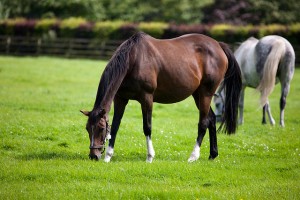
Most of the time he would have being doing this:

3765021094_f47dba227b_z

Or making foals…but you don’t need a picture of that…

Part of my research is looking for the evidence for the medieval horse studs – The word “stud” comes from the Old English ‘stod’ meaning “herd of horses, place where horses are kept for breeding” – within my study area of North Wales and North West Shropshire. There are several sources of evidence that I’ve been using and I thought I’d discuss them this week.

Firstly, there is the archaeological evidence – and this can be divided into the skeletal evidence for the horses themselves and the evidence for their horse ‘furniture’, pieces like reins, saddles and horseshoes. Skeletal evidence is, unfortunately, a bit thin on the ground, and where it does exist, for example at Aldford Castle in Cheshire (Longitude:53.130188; Latitude:-2.870270) it was very badly ‘smashed’ – that is to say, it was in pieces big enough to know it was a horse, but too small to be able to estimate the size of the horse.

I’ve previously discussed the loss of the site of Parc-y-Meirch (The Horse Park) in the blog post https://medievalparksgardensanddesignedlandscapes.wordpress.com/2013/07/08/archaeological-arrogance/ but fortunately during the rescue excavations medieval horseshoes were recovered from the site – which helped corroborate the second strand of evidence I want to discuss – the historical evidence.

Again, it is possible to divide the historical evidence into two sections, that is evidence for specific sites – such as the evidence from ‘The Survey of the Honour of Denbigh’ taken in 1334 which lists Parc-y-Meirch. The other section is the historical evidence which is non-site specific. An example of this can be found in the writings of Giraldus Cambrensis / Gerald of Wales:

“There are some excellent stud-farms. A superb race of blood-stock is now bred there, tracing its descent from the Spanish horses which Robert de Bellême, Earl of Shrewsbury, had gone to some pains to have imported long ago. The horses which are sent out from Powys are greatly prized: they are extremely handsome and nature reproduces in them the same majestic proportions and incomparable speed.”

Welsh poetry of the medieval period can also help understand the breeding programme. The poet Cynddelw Brydydd Mawr described Madog ap Maredudd (Prince of Powys from 1132-1160) as a ‘companion of Gascon horses’ and the poet Llywarch ap Llywelyn says that Llywelyn ap Iorwerth (Prince of Gwynedd 1195-1240) had Gascon horses. Gascony is in south west France (Longitude:43.763138; Latitude:-0.046619), so the importation of the horses appears to have gone on for at least a century.

Finally there is the pictorial evidence for horses in the Welsh Law Books – in Peniarth MS.28 on folio 24v there is a picture of a horse within the section of the law on horses:

mrw 090

So, as you can see from this small selection of sources, the study of horses and where they were kept and bred is full of variety and I’m really enjoying the research to find out more.

Uncategorized

Patterns in the Palimpsest

Many of my friends and colleagues have found themselves confronted with tweets, facebook messages or e-mails which usually consist of: “I’VE FOUND ANOTHER PARK!”

Whilst the response from my fellow academics is usually “Excellent!”, those not so familiar with this kind of landscape research tend to ask “How?”. So, in this blog post I thought I’d explain some of the methods used to find and identify a park as medieval and then attempt to place it in its context.

Cambridge University Library has one of five known sets of proof maps prepared for John Speed’s ‘Theatre of the Empire of Great Britaine’, which was published in 1611/12, and they are available to view online at: http://www.lib.cam.ac.uk/deptserv/maps/speed.html

Below is an extract taken from the map of Denbighshire showing the area around Wrexham, North East Wales (Latitude 53.045083; Longitude -2.9931521).

Abenbury

As you can see, there are two parks marked on the map, one of them ‘Holt Park’, but the second has no information provided for its location other than it is to the east of Wrexham. At this time the castle at Holt and its attendant town were the most important focal point for the administration of the area, whist Wrexham was a town in all but name (Wrexham was awarded its borough charter in 1857, whilst the borough of Holt was dissolved in 1886). My blog post on the excavations at Holt Castle can be found here: https://medievalparksgardensanddesignedlandscapes.wordpress.com/2013/07/26/the-boss-with-apologies-to-bruce-springsteen/

Whilst the medieval landscape of Holt has seen some academic research, the history of the park to the east of Wrexham is a little more enigmatic. The map shows that it has a very straight western boundary, and this equates to the very straight edge of the park known today as Cefn Park.

Cefn Park Map

Map of Cefn Park

Cefn Park AP

Aerial Photograph of Cefn Park

The Park is now divided into two separate estates, known as Cefn Park and Llwyn Onn. The majority of the papers relating to the estates were either lost in a fire in the house of Cefn Park, and those that do survive only extend back to the Eighteenth Century. All three depictions of Cefn Park show it as an being roughly oval in shape. This is usually an indicator that a park was laid out in the medieval period, but is it possible to be more precise with a date?

At the Marford bailiwick court held on 5 October 1333 the jurors referred back to the time when Roger de Kettley, chief forester, ‘took all the wood of Glyn, which was previously common, into a fenced enclosure for the lord’. The ‘wood of Glyn’ is now the part of the park around the National Trust property of Erddig Hall http://www.nationaltrust.org.uk/erddig/

This suggests then that a new park was required by the English Lord of Bromfield and Yale at Glyn, which is close to the former motte and bailey castle of ‘Wristleham’ (Wrexham), recorded as being in existence in 1161. This, along with a new park laid out at Holt (and recorded on the John Speed map) indicates a considerable reorganisation of the landscape.

The question therefore, is where is Cefn Park in the records of the period? The Extant of Bromfield and Yale, taken in 1315 for the new English Lord describing who owed what service to the him after he had replaced the Welsh Prince following the Edwardian Conquest of 1282-1283, appears to contain the answer.

Cefn Park is in Abenbury, and the ‘Extent’ records that it is held by Griffi ap Ior, Griff ap Hwfa, Ienna ap Hwfa and Griff ap Ior Fychan (‘ap’ is son of, Fychan is ‘little’ or ‘junior’), except one-fifth which is held from the Queen (the wife of Edward II).

These men, and their ancestors, appear to have held the land in return for carrying out services including supplying grain, gathering nuts and making and repairing some of the buildings required by the lordship administrators. All of these services needed land, and it appear then that Cefn Park was no longer a hunting park of the Princes of Powys, but had been ‘disparked’ and put to use supplying these resources.

It kept its western boundary as this was the division between it and the pasture owned by the Abbey at Valle Crucis, which they had been gifted in 1202 and the charter for which still survives.

How much older than 1202 then is Cefn Park? At the moment I’ve exhausted the sources available to me, so I suspect that archaeological excavation of the park, either its boundaries or any identifiable internal features may provide the answer.

Uncategorized

Our Dark Garden

With due deference to everyone who has tweeted, retweeted, donated or sent best wishes to me and my quest for PhD funding, I thought that this blog post should talk about some of the medieval gardens I’ve been researching, and the variety of sources available for such a study.

The earliest contemporary written evidence for the creation of gardens in Wales is to be found in the biography of a twelfth century king, Gruffydd ap Cynan, of the Welsh kingdom of Gwynedd. The Historia Gruffud vab Kenan says:

‘Then he increased all manner of good in Gwynedd, and the inhabitants began to build churches in every direction therein, and to plant the old woods and to make orchards and gardens, and surround them with walls and ditches, and to construct walled buildings, and to support themselves from the fruit of the earth after the fashion of the Romans’.

Some evidence for this reorganisation and improvement of Gwynedd has been identified, most recently by David Longley, and his research into the medieval landscape of the island of Anglesey. However, there are problems which mean that further work is still needed.

Archaeological excavations of medieval high status sites in Wales have tended to be small in scale, and to date very few high-status Llys (Royal Court) sites have been excavated. Exacerbating this is the fact that only some of the Llys site locations are known, as they fell out of use during the fourteenth century because they were no longer needed by the new administration.

The Edwardian castle at Rhuddlan (Latitude 53.288595; Longitude -3.463749) serves to highlight some of the issues which I have encountered during my research.

This castle was constructed from 1277 onwards to replace an earlier motte and bailey castle on a nearby site to the south, which in turn replaced a Llys, the location of which is most probably under the motte and bailey earthworks.

DI2010_1781

Crown Copyright DI2010_1781
The motte and bailey castle is in the trees to the right of the image.

Edward I, as part of the provision for his wife, Eleanor of Castile, and her household, had constructed for her a garden within the castle precinct between July 1282 and March 1284. The location for this has been suggested as within the inner courtyard of the castle, where it would have been overlooked by the Royal apartments.

The documentation states that encircling the head of the castle well (which had a boarded roof), a little fishpond lined with four cartloads of clay brought from the nearby Rhuddlan marsh was created and set around with seats. The adjacent courtyard was laid with 6000 turves and the lawn fenced with the staves of discarded casks.

Rhuddlan Castle was taken into state care in the twentieth century and following World War II conservation works were carried out. As part of the conservation works the moat was emptied:

DI2010_2242

Crown Copyright DI2010_2242
Excavation of the moat in 1949.

Unfortunately I have not been able to find any archaeological documentation to accompany the photographs taken, meaning any environmental evidence, including medieval plants, which may have existed within the moat has now been lost. In addition, there has been no programme of survey or excavation within the inner courtyard of castle, meaning that the location of the garden and fishpond is not conclusively identified.

During my research, I re-examined the historical sources, and found mention of a second garden at Rhuddlan Castle in 1285. This was described as a herber (a pleasure garden) opposite the north gate of the castle, and significantly, outside of the castle precinct. Fieldwork I undertook earlier this year suggests that this herber lay within the ditch to the north of the castle and may well have been accessible from the River Clwyd immediately to the west. The location of the herber is at the bottom left of the first photograph under the trees.

Further research of sites such as the Edwardian Castle of Rhuddlan will revolve around planning the best recording strategies for these two garden locations, whether that is deemed to be survey or excavation. Given that there is in close proximity an earlier motte and bailey and a Llys site, both of which are likely to have gardens of one form or another associated with them, there is exceptional potential for understanding the change and development of Royal gardening taste of both English and Welsh Royalty during the medieval period.

Uncategorized

Archaeological Arrogance?

The A55 expressway across North Wales passes many archaeological and historical sites. Many of them are preserved and respected, either by national bodies or in private ownership. Occasionally they are compromised by the whims of succeeding generations, for example the later road and rail bridges around Conwy Castle, but on the whole those which were deemed of sufficient importance were protected by legislation of one form or another.

One site I am writing about in my PhD thesis has disappeared from the landscape. I pass its former location twice a day as I drive from my house to the office and look up at the jagged hole in the skyline which was once the site of an Iron Age Hillfort.

This jagged hole was created because the solid geology which made up the Hillfort was Limestone, and the Limestone was needed to provide the flux in the blast furnaces for making steel at the nearby steelworks in Shotton, but what of the archaeological and historical significance of this site being removed lorry load by lorry load?

The most recent name for this site is Dinorben (Latitude 53.265522; Longitude -3.545362). The voracious appetite of the steelworks saw an intermittent programme of archaeological excavations from 1912 to 1978, with the result that the understanding of the archaeological context of the Hillfort is now well understood through various publications.

Or is it?

This Hillfort has previous, both archaeological and historical, which has been neglected in the drive to tell one story over another. In 1334, the Hillfort was recorded in ‘The Survey of the Honour of Denbigh’. This is one of the extents which I mentioned in a previous blog post (https://medievalparksgardensanddesignedlandscapes.wordpress.com/2013/06/23/si-longtemps-et-merci-pour-le-poisson/) and which were compiled in the Fourteenth century describing who owed what service to the ‘new’ English Lord of the Manor – who had replaced the Welsh Prince after the Edwardian Conquest of 1282-1283.

The Hillfort is known as ‘Pendinas’ (Top of the City) and is described as a wood of nearly five acres, covered with poor scrub and in the possession of Johannes of Rhuddlan. Whilst ‘Pendinas’ may have been the official name, by the time the archaeologists arrived in the early Twentieth century it was known as ‘Parc y Meirch’ (The Horse Park). The Hillfort defences were reused during the medieval period as the location of a horse stud, and if the horses were ill, then they could avail themselves of a holy well, dedicated to St. Siôr, titular saint of horses.

This narrative however, merited only the briefest of mentions in the archaeological reports produced on the site, and the archaeologists changed the name of the site from ‘Parc y Meirch’ to ‘Dinorben’ – the name of a land division. Quite why the archaeologists felt the need to change the name I’ve yet to fully decipher, but it appears that medieval name and story was known by the archaeologists, but it did not fit with the story they wished to tell.

To compound the issue further the medieval finds, consisting of horse shoes and pottery, were confined to an appendix of the main site report written in the late 1960s and early 1970s. The reason for this confinement may be because the principal archaeologist was a prehistorian, and again, the story was not the one which needed to be told.

Parc y Meirch is a very important site in terms of understanding how a medieval horse stud related to the wider landscape within my PhD study area. The side lining of one interpretation over another because it does not fit your personal archaeological aims can never help the overall understanding of a monument in a landscape, and ensuring that archaeological and historical evidence is presented in a balanced manner will always advance the archaeological agenda, even if you don’t agree with the findings, or even the name of the place you are excavating.

Uncategorized

Si longtemps, et merci pour le poisson

Writing a PhD thesis can raise questions you never thought you would have to contemplate finding an answer for when the research began. I assumed (naively perhaps) that I would just sit down, write about Welsh Castles, show where their landscapes were and be made a Doctor.

Except it doesn’t really work like that.

You sit down, start writing, and then find a reference. This reference takes you off to a book you’ve never heard of – and before you realise it a whole sub-plot has appeared in your research.

Which is what happened to me with the Otters.

It all began so innocuously. As part of my reading I have to look at the medieval extents which were compiled in the Fourteenth century describing who owed what service to the ‘new’ English Lord of the Manor – who had replaced the Welsh Prince after the Edwardian Conquest of 1282-1283. Within them I found a reference to something called ‘Cylch Dyfrgwn’ – with literally translated means ‘Otter Circuit’.

As an archaeologist, I’d never heard of an ‘Otter Circuit’. And, having thought about it, I’d not read about any otter bones being found on the excavations I’d been reading about. Was there a connection between the two?

An ‘Otter Circuit’ was a service which had been carried out under the Welsh Princes, and which was subsequently carried over to the English Lords. Essentially it was a hunting party who travelled around a prescribed piece of land from place to place keeping the ‘uneatable’ animals under control, of which the otter was classed as one.

Just because the animals were ‘uneatable’ did not mean that the event to hunt them was not without symbolism and ceremony. The ‘Devonshire Tapestries’, now in the Victoria and Albert Museum and dating to the Fifteenth century depict an otter hunt in detail http://www.vam.ac.uk/content/articles/d/devonshire-hunting-tapestries/ and, although stylised, the detail of the hunting equipment and methods is clearly depicted. The main piece of equipment, a two pronged spear, continued to be used unchanged well into the Twentieth century.

otterhunt

The lack of archaeological evidence for the Otters from the ‘Otter Circuit’ can be explained by the fact that they were killed where they were caught, so the remains which were not useful were left at the spot. The skins were subsequently used for high-status clothing, and unfortunately these materials have not survived to the present day.

I’ve probably spent way too much time unpicking this story to try and understand the place of Otters in the medieval world, but the data I’ve collected can be used by modern researchers to understand the medieval range of the Otter and hopefully aid in ensuring the continued growth of the population.